I don't think anyone reads this, but I plan on closing this down at the end of the year (Dec. 31, 2016). I lost my vision for Aurora. The only reason I have it still up for now is because there might be something useful. So if you like anything, grab it now before it disappears.
Update 3/24/17: I guess I will keep it going, to comment on the "culture", such as it is, of Aurora.
Wednesday, November 30, 2016
Tuesday, October 25, 2016
The Smoky Hill Trail

Source: http://www.smokyhilltrail.com/maps.htm
The Smoky Hill Trail was a 592 mile stagecoach trail from Atchison KS to Denver, CO, in use from 1855 to 1870. It is named after the Smoky Hill River in Kansas, because the trail ran next to it. Part of the middle branch of the trail today is called Smoky Hill Road.
The north branch of the trail is followed by US-40 and I-70 today. But it was first called Kansas City Road or Grand Avenue, before being renamed "Colfax Avenue" in 1865 for Schuyler Colfax.
Saturday, October 15, 2016
Colfax & Florence
The old People's Rent To Own building is being converted to a performing arts center and restaurant at a cost of $2.6 million. See http://www.aurorasentinel.com/news/business/colfax-new-light-auroras-2-6m-peoples-investment-good-grander-vision-falls-short/ Unfortunately, even at that cost, the stage will be to small to accommodate a dance troupe.
Thursday, October 6, 2016
Friday, September 2, 2016
Sterling Ranch Town Center

Just beautiful. This is located in Douglas County, south of C-470 and west of Highway 85, near Roxborough Park.
Thursday, September 1, 2016
The Buckley Buffer
Note: This video is unlisted and may disappear. See the original link at https://www.tpl.org/our-work/parks-for-people/buckley-air-force-base
I personally don't see the need for so much open space in this area. Most of Buckley is undeveloped and to the south is the Plains Conservation Center, which is 1000 acres of prairie and weeds. It is not like this is beautiful woodlands or wetlands or something. This is after all, in a city, and right next to a major road (Jewell) and next to a major freeway (E-470). There is plenty of land to the east for open space if needed.
Kirkegaard Acres
This is one of the oldest neighborhoods in Aurora. It is 100 acres located to the southeast of Airport & Colfax.
You don’t need a time machine to see what a typical Aurora neighborhood was like in the early 20th century. Tucked behind the buzz of East Colfax Avenue and East 14th Drive is an enclave of homes that look like farmhouses, where horses graze on spacious backyard lands. But horses and humans aren’t the only residents here. Raccoons, foxes, coyotes, skunks, great horned owls and red-tailed hawks also set up camp in the tall grasses and towering trees, just as they did a century ago. Members of the Danish Kirkegaard family settled the neighborhood in the early 1900s when East Colfax Avenue wasn’t so much an avenue as it was a dirt road paved well enough for horse-drawn-carriages. One of the Kirkegaards helped prepare the road by using mules to haul dirt. Yes, at one point there were furry, smelly quadrupeds moseying along Colfax.
http://www.aurorasentinel.com/aurora-magazine/features/simplicity-kirkegaard-acres/
Aurora getting piece of Stapleton

Source: http://www.denverrealestatewatch.com/2016/08/17/aurora-getting-piece-of-stapleton/
This new parcel will add an additional 27 acres to the current 63 acres in Bluff Lake neighborhood and will feature 322 new home base pricing from the high $200,000s to $400,000s, from six of Stapleton’s long standing builders.
1377 S Genoa Way
This is a vacant lot of 1.04 acres for sale at $68,500. See: http://www.loopnet.com/Listing/19715528/1377-S-Genoa-Way-Aurora-CO/
The problem is that it is zoned industrial. If it were zone residential, it would be worth at least $400,000. So what would you do with it, build a warehouse? Still the price is fantastic.
Update: The land is totally unusable because S Genoa Way has not yet been built in the area. So the person who buys it will have to sit on it for the next 20 years or longer until the area is developed.
4 Aces Bingo

Source: http://www.superpages.com/bp/aurora-co/4-aces-bingo-L0016810267.htm
4 Aces Bingo Hall, at 16000 E Colfax Ave, is now closed and for sale. They want $1.9 million for it. I think they should cut the price to under a million if they want to sell it anytime in the next 6 months.
But, but, but ... a small piece of vacant land at 16350 E Colfax sold for $3.1 million only a few months ago, so who knows. Maybe it is the Chinese. Update: That price includes the apartment building next door at 16300 E Colfax.
Tuesday, August 30, 2016
Colorado Science and Technology Park

Source: https://www.auroragov.org/UserFiles/Servers/Server_1881137/File/Business%20Services/Development%20Center/Transit%20Oriented%20Development/Fitzsimons/024173.pdf
I just noticed that they are planning on bulldozing Fitzsimons Golf Course to do this. I wonder how long it will be before this happens - probably at least 20 years.
Monday, August 29, 2016

15991 E 13th Place
See: http://www.loopnet.com/Listing/19834999/15991-East-13th-Place-Aurora-CO/
The land is for sale, only $65,000 for 0.55 acres. A great location for an apartment building. The only problem is that access is horrible. Still the price is fantastic.
Update: Already sold.
The land is for sale, only $65,000 for 0.55 acres. A great location for an apartment building. The only problem is that access is horrible. Still the price is fantastic.
Update: Already sold.
Tollgate Creek Commons

Source: http://www.loopnet.com/Listing/16992902/1100-Dillon-Way-Aurora-CO/
The address is 1100 Dillon Way, Aurora, CO 80011. The seller wants $8,050,000 for 15.4 acres just south of the 13th Avenue light rail station. It would be a great location for upscale apartments.
This is just south of the new apartment complex that will be built where the Meadows mobile home community is now.
Trolley Station

This is a proposed development at 16631 E Colfax Ave, which is on the northwest corner of Airport & Colfax. The land is for sale. A price isn't listed but I think $10 million sounds about right ($400,000/acre x 24.5 acres).
Link: http://www.landandfarm.com/property/Trolley_Station-2959417/
Saturday, August 20, 2016
Schlotzsky's

In front of Sam's Club, near Abilene & Mississippi. It has been sitting empty for awhile.
Friday, August 19, 2016
Proposed BRT lines

Source: http://www.copirgfoundation.org/sites/pirg/files/reports/COPIRG%20Transit%20Report_Screen.pdf
So Aurora gets nothing, other than the Colfax and Parker lines. What about Tower Road? Iliff/Jewell?
Tuesday, August 16, 2016
East Reservoir
The East Reservoir, which city officials began researching as a site in 2012, would sit just east of the Aurora Reservoir on the former Lowry Bombing and Gunnery Range. Darling said it could be completed in the next decade. Aurora Water is still in the land acquisition process with the Colorado State Land Board and the Rangeview Metropolitan District.
Darling said the East Reservoir project has been held up in part by federal agencies, who for years have been working to find unexploded ordinances that potentially remain on the site and could be harmful if not detonated properly.
http://www.aurorasentinel.com/news/city-officials-say-aurora-close-purchasing-additional-water-storage/
http://www.aurorasentinel.com/news/city-officials-say-aurora-close-purchasing-additional-water-storage/
Monday, August 15, 2016
You can check out any time you like, but you can never leave

Location: Hampden & Florence
Welcome back to the Nightclub California. Home of one failed dance club after another. It has been vacant for about two years.
There is also a closed 50 cent do-it-yourself carwash about a block away with a fence around it.
Westminster Station

Source: http://www.ci.westminster.co.us/Portals/0/Repository/Documents/CityGovernment/Community%20Development/DRAFT%20-%20Westminster%20Station%20Area%20Specific%20Plan%20-%20July%2011,%202016.pdf
The road on the right side is Federal Boulevard.
Saturday, August 13, 2016
Proposed Parker-Brighton Highway

Source: http://reason.org/files/reducing_congestion_denver.pdf
This is an interesting concept for a proposed Parker-Brighton Highway, which would follow Parker Road/CO 83 in the south, Buckley/Airport Blvd/Pena Blvd/Tower Rd in the middle section, and US 85 in the north. If we use $30 million per line item as a quick cost estimate, with 35 line items, this would cost about $1 billion, to be paid for with tolls.
Wednesday, August 10, 2016
Westminster Center Station

Beautiful drawing, but I think it will be at least 10 years until this is done. Right now the rail station ends near 72nd & Federal.
See also: Westminster Mall Fiasco
Monday, August 8, 2016
Proposed Jewell light rail corridor

I did this freestyle in Paint in about 5 minutes. But you can get the idea. Stations at Aurora Town Center, Alameda & Chambers, Alameda & Buckley, Tower & Mississippi, Jewell & Genoa, Jewell & Gun Club, Jewell & Harvest, Jewell & Powhaton.
Sunday, August 7, 2016
Thornton Development Map

Source: https://www.cityofthornton.net/government/citydevelopment/planning/Documents/master-plans/transportation-plan/FutureLandUse_11x17.pdf
Thornton will extend all the way to 168th Avenue.
I-70 Reimagined
This video cracks me up, it is so crazy and will never happen. Tear down the freeway and plant trees instead! But I like the out-of-the-box thinking going on here.
Nob Hill
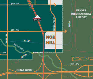
Located five minutes from the airport’s front door, Nob Hill’s immediate visibility and access to DIA make this a prime privately held piece of property. Sharing boundaries immediately at DIA’s western border and Pena Boulevard, the site offers unique views both back to DIA’s iconic terminal and also to the Colorado Rockies and downtown Denver. Nob Hill has a unique access point to the western gate of DIA with the potential of securitized access to DIA’s western airfield and the renewable energy sector of DIA as well as quick access to DIA’s current car rental and air cargo facilities. Nob Hill is a premier location for airport conference/ hospitality, airport technology businesses, support services to DIA, flex-tech and retail. Current access is available to the site at 88th and E-470 with additional future access provided as part of the aerotropolis development plan.
http://www.commercecityaerotropolis.com/wp-content/uploads/2012/10/Cowley-Brochure_FINAL.pdf
Walmart to open e-commerce facility at DIA
The real estate arm of Wal-Mart Stores Inc. has purchased 169 acres of land zoned for industrial use just south of DIA, according to a warranty deed filed in Adams County last month. Wal-Mart Real Estate Business Trust paid $13.5 million for the land, located near the intersection of East 56th Avenue and Jackson Gap Road in the proposed Porteos mixed-use development site.
Amazon.com in April announced that it would establish an e-commerce center of its own, located in Aurora at Majestic Commercenter, 19799 East 36th Dr. But according to Wendy Mitchell, president and CEO of the Aurora Economic Development Council, that center sits on just 25 acres, significantly less than what Wal-Mart purchased.
--http://www.bizjournals.com/denver/blog/real_deals/2016/08/walmart-buys-169-acres-near-dia-for-what-could-be.html
Saturday, August 6, 2016
Washed Up

Dalke's Laundry has been at Colfax & Yosemite for many years. But now it is closed and plywood covers the windows and doors.
Update 3/31/2017:
This building has now been demolished. No word on what will be built there next.
Woody's Pizza is Fired

The address is 7095 E Evan Avenue, near Quebec & Evans. The location is good, the building is in good shape. It would be a good location for a sports bar. But it has been empty about a year.
Tuesday, August 2, 2016
Eyesore on Iliff

This building at 10575 E Iliff Avenue, appears to have been troubled for a long time. Google has a series of images of it dating back to 2007. In 2011-2014, it housed a Safelite AutoGlass, but before and after that it was empty. Now there is plywood covering the windows, which is a sure sign that the owner has given up on renting it.
This is the 3rd empty or blighted building I have featured in the immediate area, the others being the old Barn Store, and the empty Village on the Park. There is also a vacant 4 acre plot of land on the NW corner of Jewel & Havana, about 4 blocks away from this.
Sunday, July 31, 2016
Rueter-Hess Reservoir

Source: http://www.castlepinesconnection.com/news-2016/phase-two-of-rueter-hess-reservoir-recreation-master-plan-begins
This is bigger than Cherry Creek Reservoir.
Colfax Bus Rapid Transit

Source: http://www.apacolorado.org/article/arriving-brt-colfax-corridor-connections
I don't like it. I like the idea of Bus Rapid Transit, since it is a lot more flexible and cheaper than light rail, but I think this should be elevated so it won't take up two lanes of traffic and so it won't have to stop at lights.
Paradise Lost
 |
| Empty Restaurant at 15500 E 6th Avenue, near Chambers Rd |
This was formerly known as the Paradise Club.
Update 5/8/2017. It is still empty. It was formerly also a Marie Callender's, and at one point was a Tamale Kitchen. The address is alternately given as 15500 E Centretech Pkwy, Aurora, CO 80011.
Saturday, July 30, 2016
Another Ley Line
Wow, I just discovered another ley line. I don't feel like take screenshots, you will just have to follow along on a map. This one starts at E Mississippi and S Chambers. Follow a line southwest to the west side of the King Soopers. There is a green grassy area bordered by S Chambers Cir & E Alabama Pl. This leads into the south edge of Gateway High School, which is angled slightly off but very close to the line.
Follow this across Sable and it follows a fence line. It is bad feng shui or something to build directly on the line but good feng shui to parallel it. This is paralled by E Arkansas Dr and then E Idaho Dr. Then it crosses the intersection of E Florida and Iowa where there is an apartment complex with all the buildings parallel to the line. It follows a concrete footpath just south of one of the buildings. And then you can see there is an angled street that follows the line.
It then crosses I-225 and there is a small office building that is built on alignment with the line, along with the parking lot in front of it. It then disappears in the Jewell Wetlands Park, but follow the same line and you see that Overland High School and Prairie Middle School next door are built along the line with roads and parking lots. Follow this to the southwest and you see a dirt road that follows it.
It then seems to disappear again and crosses Peoria just north of Iliff. It crosses Iliff at Oswego. It then runs along E Vassar Dr, and it crosses E Parker Road right where Yale intersects with it.
It crosses Havana and runs along the Hampden Heights Trail all the way to the intersection of Hampden & Yosemite where it ends.
The Great Aurora Gas Ley Line
A ley line is an invisible grid line that may have some spiritual and mystical significance. In Aurora, there is a ley line that follows an underground gas line. It begins just north of the northeast corner of S Chambers Road and E Center Ave, where it is marked by a pair of signs warning about a gas pipeline underneath. From there it continues southeast at an approximate 45% angle for at least 20 miles. It runs parallel to S Sampson Gulch Way south of Arapahoe Road and east of E-470, but traces of it run even farther southeast. Many streets and houses lie parallel to it. There is only one building built on it, which is a Roman Catholic church northeast of Tower and Hampden. It can best be seen on a satellite map. Here is the northwest part of it.
 |
| Northwest Corner of the Aurora Ley Line at S Chambers & East Center Ave |
 |
| Rangeview High School is built parallel to the ley line |
 |
| St Michael the Archangel Church is built directly on the line |
 |
| Eaglecrest High School is also built parallel to the line, which is on the west |
 |
| The ley line parallels E Irish Dr, which turns in to S Sampson Gulch. |
Friday, July 29, 2016
First Creek Park Open Space

56th Avenue & Buckley Road is on the southeast corner of the Rocky Mountain Arsenal. Before DIA was built, you could drive along Buckley all the way along the perimeter of the Arsenal. Now Buckley is blocked off. You could park in the parking lot and walk north along the road, but it isn't that exciting. The traces of an old trailer park are still visible from the air. Although the RMA is now open to the public, there is no way in from this side.
This property is now designated the "First Creek Park Open Space" (which is it, park or open space?) also known as "First Creek at DEN Open Space". I find it very interesting because it still has a "Cold War" vibe about it coming from the RMA. Also, it seems post-industrial, with the asphalt road that you can't drive on anymore and the old trailer park. This was once part of civilization, but it now has reverted to being wilderness. And most of all, it is very close to the light rail station at 61st Avenue, and the area around it may be some of the most futuristic in the country, with the Panasonic SmartCity being built there.
Century 21 Raceway


Source: https://www.uer.ca/locations/viewgal.asp?picid=330996
On the southeast corner of Picadilly & Smith Road, you can see the remains of an old raceway called "Century 21 Raceway". Now it is just empty, but a project called "ProLogis East Gate" will be built there.
See also Abandoned Race Track.
New Alameda Center

Source: https://www.facebook.com/g3architecture/photos/
G3 Architecture has designed a fantastic mixed-use center at the northeast corner of Sable and E Alameda. I love it.
See also Dysfunction Junction.
Eastbridge Town Center

A new King Soopers is being built to anchor the site at MLK & Havana. MLK Blvd will soon be extended to meet up with Fitzsimons Parkway.
Thursday, July 28, 2016
Aurora Airpark

On the southeast corner of I-70 and Monaghan Road is an interesting piece of land. There is a diagonal slash through it, that looks like a road. What few people know is that it is an abandoned runway and planes flew out of Aurora Airpark as late as 2004, with an average of 60 takeoff/landings per day.
Note that this was one of FIVE airports in the Aurora area. The others were Stapleton, Lowry AFB, Buckley, and Front Range Airport.
Titan 1 Missile Silo Complex 724A

Source: http://i.imgur.com/z5aQahH.jpg
This is located near what would be Hampden Ave & Harvest Rd, if those roads were built, which they probably won't be. I wonder if they will build houses right next to this. Probably not. So the whole gigantic area between Gun Club Rd on the east, Powhaton Rd on the west, Yale on the north, and Quincy on the south will probably be set aside as another giant wildlife preserve. This includes the Lowry Landfill, and the Pronghorn Natural Area. This is about 4 square miles.
Among its neighbors will be a residential neighborhood/golf course to the north, the former Plains Conservation Center (now an Aurora park) to the east across E-470, and the Arapahoe County Fairgrounds to the south, with the Aurora reservoir further south.
All this massive open space isn't necessarily a bad thing, but it will suck the energy out of city life. I'm sure there will be some very nice housing developments to the east, but they will be more boring urban sprawl, which again isn't a bad thing, if you are looking for a quiet place to raise kids. Who in their spare time can investigate the underground abandoned missile complex.
Poor Wendy

This Wendy's near Yosemite & Hampden closed sometime after Aug 2015. There are also closed and abandoned Wendy's at 2720 Baseline Dr in Boulder, 304 Center Dr in Superior, and near Parker & Chambers, which I previously mentioned.
Abandoned Albertson's in Northglenn

Near 104th & Huron in Northglenn, Albertson's moved out in 2006, and the space has been vacant ever since. Northglennn is considering condemning the property.

Wednesday, July 27, 2016
The old Barn Store

On the northwest corner of Parker Rd & Iliff, in unincorporated Arapahoe County, sits an abandoned Barn Store, which used to also have a small 4-pump gas station. It closed sometime in 2013 or 2014, and I think it could be called blighted. It seems like a prime location, tens of thousands of cars rushing by every day. Yet it sits empty, unloved, forlorn, lonely, waiting for someone to put it out of its misery.
The empty Village on the Park

There is a triangle formed where Iliff, Havana, and Parker Road meet. On the southeast part, south of the Ross Dress for Less building, is a large rectangular building (across from the Stampede), and in front of it is a small building that looks like a house, which used to house a Le Peep. The two buildings are owned by Kimco Realty from New Hyde Park, NY, which owns more than 700 commercial properties nationwide. An Aurora Sentinel article called it "Village on the Park", but I haven't seen that name anywhere else.
The Le Peep restaurant has been empty since 2012, and the rectangular building has been nearly empty for a long time, with its last tenant, Space Age Federal Credit Union, moving out in 2015. There was some talk of it being set to be demolished last year, but still the two buildings sit empty, year after year.
They aren't blighted - no broken windows, plywood or graffiti, and they seem to be in good shape, just functionally obsolete. And yet they sit empty, waiting to be demolished.
Will anything happen this year? It seems doubtful. Meanwhile, over 100,000 cars per day, zoom by.
Tuesday, July 26, 2016
Future Iliff-Jewell light rail corridor

Source: https://www.auroragov.org/UserFiles/Servers/Server_1881137/Image/Departments/Development/SEATS.pdf
Longer-term transit service (post 2030) could potentially include rapid transit. The median within
E-470 has been identified for a future rapid transit facility, exact nature unknown at this time.
Jewell Avenue has also been identified for possible rapid transit service extending into the
NEATS area from the west.
Note: The light rail line extends west from the E-470 interchange. The only explanation I see is that it will extend all the way to Iliff/I-225. Since there is no room on Iliff for light-rail, I think it will be elevated.
Another Map

From: http://www.cbre.us/o/denver/AssetLibrary/Aurora_Crossroads_Bro1.pdf
"Site" refers to the Aurora Crossing project.
Map of master planned areas

From: https://www.auroragov.org/UserFiles/Servers/Server_1881137/Image/Departments/Development/SEATS.pdf
This is from 2007, which shows how long the city has been thinking about this, and how little has been done.
Eastern Aurora Annexation Study Area

From: http://auroramediagrp.wpengine.netdna-cdn.com/asuplads/EastAnnexationStudyArea.jpg
Since each square represents a square mile, this is a huge map.
Sunday, July 24, 2016
Metro Transportation Projects through 2035
http://www.metromayors.org/AgendaCenter/ViewFile/Agenda/06132013-30
This is an interesting document listing hundreds of projects road improvements and transportation projects in the Denver area.
This is an interesting document listing hundreds of projects road improvements and transportation projects in the Denver area.
6th Avenue Parkway Extension
Aurora is moving ahead with plans to extend Sixth Avenue from its curved diversion over and around Buckley Air Force Base to a more straight shot out east to E-470. The proposed direct line connection from a bit west of Piccadilly Road to the E-470 diamond interchange at Sixth Avenue is necessary to improve connectivity and transit time to the eastern parts of the city.
http://www.denverpost.com/2015/12/29/aurora-will-extend-6th-avenue-straight-to-e-470-after-decades-of-plans/
http://www.denverpost.com/2015/12/29/aurora-will-extend-6th-avenue-straight-to-e-470-after-decades-of-plans/
The Aurora Street Grid
The city of Aurora is a ravenous beast seeking to expand half-way to Kansas. Here is an incomplete list of the North-West streets in Aurora, and some of them are guesses. Major boulevards are in bold. There are 16 streets in a mile, and the zero point is Broadway in Denver. Yosemite is roughly the western border with Denver and it is about 5.5 miles east of Broadway. Schumaker is the far east border of Aurora and is about 28.5 miles east of Broadway. So Aurora is 23 miles long from west to east.
8900 E Yosemite
9000 E Akron
9100 E Alton
9200 E Beeler
9300 E Boston
9400 E Chester
9500 E Clinton
9600 E Dallas
9700 E Dayton
9800 E Emporia
9900 E Elmira
10000 E Florence
10100 E Fulton
10200 E Galena
10300 E Geneva
10400 E Hanover
10500 E Havana
10600 E Iola
10700 E Ironton
10800 E Jamaica
10900 E Joliet
11000 E Kenton
11100 E Kingston
11200 E Lansing
11300 E Lima
11400 E Macon
11500 E Moline
11600 E Newark
11700 E Nome
11800 E Oakland
11900 E Oswego
12000 E Paris
12100 E Peoria
12200 E Quari
12300 E Quentin
12400 E Racine
12500 E Revere
12600 E Salem
12700 E Scranton
12800 E Troy
12900 E Tucson
13000 E Ursula
13100 E Uvalda
13200 E Vaughn
13300 E Victor
13400 E Wheeling
13500 E Worchester
13600 E Xanadu
13700 E Potomac
13800 E Abilene
13900 E Atchison/Anaheim
14000 E Billings
14100 E Blackhawk
14200 E Carson
14300 E Crystal/Cimarron
14400 E Dillon
14500 E Sable/Dawson
14600 E Dearborn
14700 E Eagle
14800 E Elkhart
14900 E Altura/Evanston
15000 E Fairplay
15100 E Frasier
15200 E Granby
15300 E Chambers Rd
15400 E Hannibal
15500 E Helena
15600 E Idalia
15700 E Jasper
15800 E Joplin
15900 E Kalispell
16000 E Kittredge
16100 E Laredo
16200 E Lewiston
16300 E Memphis
16400 E Mobile
16500 E Norfolk
16600 E Nucla
16700 E Olathe
16800 E Ouray
16900 E Buckley/Airport Rd
17000 E Pagosa
17100 E Pitkin
17200 E Quintero
17300 E Richfield
17400 E Rifle
17500 E Salida
17600 E Sedalia
17700 E Telluride
17800 E Truckee
17900 E Uravan
18000 E Ventura
18100 E Waco
18200 E Walden
18300 E Yampa
18400 E Zeno
18500 E Tower Rd
18600 E Andes
18700 E Argonne
18800 E Bahama
18900 E Biscay
19000 E Cathay
19100 E Ceylon
19200 E Danube
19300 E Dunkirk
19400 E Ensenada
19500 E Espana
19600 E Flanders
19700 E Fundy
19800 E Genoa
19900 E Gibralter
20000 E Halifax
20100 E Himalaya
20200 E Iran
20300 E Ireland
20400 E Jebel
20500 E Jericho
20600 E Killarney
20700 E Kirk
20800 E Lisbon
20900 E Liverpool
21000 E Malaya
21100 E Malta
21200 E Nepal
21300 E Netherland
21400 E Odessa
21500 E Orleans
21600 E Perth
21700 E Picadilly
21800 E Qatar
21900 E Quemoy
22000 E Riviera
22100 E Rome
22200 E Shawnee
22300 E Sicily
22400 E Tempe
22500 E Tibet
22600 E Ukraine
22700 E Valdai
22800 E Versailles
22900 E Wenatchee
23000 E Winnipeg
23100 E Yakima
23200 E Zante
23300 E Gun Club Road
23400 E Alonquian
23500 E Addison
23600 E Biloxi
23700 E Buchanan
23800 E Catawba
23900 E Coolidge
24000 E Duquesne
24100 E De Gaulle
24200 E Elk (Delta - Brighton)
24300 E Eaton Park
24400 E Flat Rock / Flatrock
24500 E Fultondale / Fulton (Fortune - Brighton)
24600 E Grand Baker / Grandbay
24700 E Gold Bug
24800 E Haleyville
24900 E Harvest Road (Weld County 39)
25000 E Irvington St
25100 E Ider St
25200 E Jackson Gap
25300 E Jamestown
25400 E Kewaunee
25500 E Kellerman
25600 E Langdale
25700 E Little River
25800 E Milbrook
25900 E Muscadine
26000 E Newbern
26100 E New Castle
26200 E Oak Hill
26300 E Old Hammer
26400 E Patsburg
26500 E Powhaton Road
26600 E Queensburg
26700 E Quantock
26800 E Riverwood
26900 E Robertsdale
27000 E Shady Grove
27100 E Scottsburg
27200 E Titus
27300 E Trussville
27400 E Uriah
27500 E Undergrove
27600 E Valley Head
27700 E Vandriver
27800 E Waterloo
27900 E White Cross / White Crow
28000 E Yantley / Zuging
28100 E Monaghan Rd [Adams 21]
28200 E ???
28300 E ???
28400 E Bentley
28500 E ???
28600 E ???
28700 E ???
28800 E ???
28900 E Del Ray
29000 E ???
29100 E Electra
29200 E ???
29300 E ???
29400 E Gadsden
29500 E Great Rock
29600 E ???
29700 E Hayesmount Rd [Arap 89]
29800 E Indian Hill (Brighton)
29900 E Iredell (Brighton)
30000 E Jalna (Brighton)
30100 E Joppa (Brighton)
30200 E Kenuil (Brighton)
30300 E Kenvil (Brighton)
30400 E Lakewood (Brighton)
30500 E Lane Wood (Brighton)
30600 E Lindark (Brighton)
30700 E Maywood (Brighton)
30800 E Meadow Woods (Brighton)
30900 E Northridge
31000 E ???
31100 E Overton (Brighton)
31200 E ???
31300 E Hudson Rd / Hudson Mile Road [Adams 23, Weld 47]
31400 E Queensview (Hudson)
31500 E Rayburn (Hudson)
31600 E Red Lane (Hudson)
31700 E Shadow Wood (Hudson)
31800 E Stroil (Hudson)
31900 E Timber Cove (Hudson)
32000 E Tree Haven (Hudson)
32100 E Umpire (Hudson)
32200 ???
32300 ???
32400 ???
32500 ???
32600 E Denver Ave (Watkins)
32700 ???
32800 ???
32900 E Watkins Rd [Adams 24]
33000 E
33100 E
33200 E
33300 E
33400 E
33500 E
33600 E
33700 E Eclectic St (Watkins)
33800 E Eclipse St
33900 E ???
34000 E Fountain Hill
34100 E Gentry
34200 E ???
34300 E Hanover
34400 E Haskell / Haskill
34500 E Imboden Rd [Adams 25]
34600 E Inyokern Ct (Watkins)
34700
34800 E Kio (Watkins)
34900 E Kirby (Watkins)
35000
35100
35200
35300
35400 E Nashville
35500
35600
35700
35800 E Perrytown
35900
36000
36100 E Quail Run Rd / Almstead Rd
36200
36300
36400
36500 E Snow Lake
36600
36700
36800
36900 E Ulm / Bonnie Lane
37000
37100 E West Fork
37200
37300 E Front Range Parkway
37400
37500
37600
37700 E Cavanaugh Rd [Arapahoe 109, Adams 27]
37800 E Avery
37900 E Barkdaly
38000
38100
38200
38300 E Flint Ridge (Bennett)
38400 E Flint Rock
38500
38600
38700
38800
38900
39000
39100
39200
39300 E Manila Rd [Adams 28, Arap 113]
39500 E Indianfield St
39600
39700
39800
39900 E Kiefer
40000 E Lookout Hill
40100 E Last Chance Rd
40300 E Musk Ox
40500 E Nutmeg
40700 E Oakleaf
40800 E
40900 E Peterson Rd [Adams 29, Arap 117]
41600 E Split Rock (Bennett)
41700 E Tom Bay
41800 E Tumbleweed
42500 E Schumaker Rd [Adams 30, Arap 121] (Aurora)
----------------------------------------------------
43300 E Dutch Valley Rd [Arap 123] (Bennett)
44100 E Harback Rd [Adams 31] (Bennett)
45700 E Penrith Rd / Brick-Center Road [Adams 32] (Bennett)
47300 E Converse Rd / S 1st St [Adams 33] (Bennett)
48900 E Kiowa-Bennett Rd (Bennett)
50500 E Provost Rd [Adams 35] (Bennett)
52100 E Yulle Rd [Adams 36] (Bennett)
52200 E Ajax (Strasburg)
52300 E Barres (Strasburg)
52400 E
52500 E Donaven (Strasburg)
52600 E Doppler St (Strasburg)
53700 E Wolf Creek Rd [Adams 37] (Strasburg)
55300 E Piggott Rd [Adams 38] (Strasburg)
55400 E Quarterland (Strasburg)
55500 E Renshaw (Strasburg)
55600 E Rose Hill (Strasburg)
56500 E Wagner (Strasburg)
56800 E Yerkes (Strasburg)
56900 E Strasburg Rd [Adams 39] (Strasburg)
57000 E Ance
57100 E Asoka
57200 E Basil
57300 E Comanche
57600 E Defoe
57800 E Flandin
58500 E Headlight Rd [Adams 40] (Strasburg)
60100 E County Rd 165
61700 E Yellow Jacket Road
63300 E Bradbury Rd / Bradbury Krebs [Adams 43, Arap 173] (Byers)
64900 E Jewell St (Byers)
66500 E Exmoor Rd [Arap 181] (Byers)
68100 E County Rd 185 / Calhoun Byers Rd
69700 E Quail Hollow Rd (Byers)
71300 E County Rd 193
74500 E County Rd 201 / Peoria Rd
80900 E Price Rd
82500 E Huntington Road
I guess I find it interesting that the Aurora street grid continues so far out in the plains. There is actually a house in Watkins with the address of 32845 E Colfax Avenue. And one in Strasburg with the address of 57030 E 18th Avenue.
Quincy Avenue continues far out east so there is an intersection of Quincy & Wolf Creek, Quincy & Strasburg, and finally Quincy which turns north into Bradbury, near Byers. It's a dirt road. It's definitely outside the Aurora planning area.
Update: The grid goes even further east. There is an Alameda Avenue in Byers which is north of I-70, because I-70 curves to the south. There is also a Jewell Avenue, and a Yale Avenue. 15th Avenue (it would be cool if they called it Colfax), continues into Deer Trail. So parts of Deer Trail are on the same grid.
More: There is a Hampden Avenue in Deer Trail which is north of I-70. It looks like the grid continues in places all the way to the border with Washington County, Meridian Road, which is 109700 E, which is 68.5 miles east of Broadway. This is roughly north of Limon (in Lincoln County), which is about 90 miles from the Kansas border.
Saturday, July 23, 2016
Trails on the Plains

Source: https://www.codot.gov/projects/aerotropolis/reports/visioning-study-infrastructure.pdf
I find this map to be fascinating, not because I am really interested in the trail system, but because of the way it shows the street grid so far out east.
Major east-west streets: 48th Avenue, 26th Avenue, (I-70), 6th Parkway, Alameda Ave, Mississippi, Jewell, Quincy Ave
Major north-south streets: Picadilly Rd, (E-470), Gun Club Rd, Harvest Rd, Powhaton Rd, Monaghan Rd, Havesmount Rd, Hudson Rd, Watkins Rd.
Aerotropolis
This has nothing to do specifically with DIA, but presents the concepts of the Aerotropolis. Some of these shots look like the new light rail terminal at DIA.
Death by Light Rail

Bennett's Bar-B-Que served delicious barbeque at 37 & Peoria for 25 years. But the new Peoria Street overpass was built to accommodate the light rail and old Peoria became a frontage road that was very difficult to access. The restaurant closed about June 2015 and its main use now is as a parking lot for buses. A new Bennett's BBQ opened on Arapahoe Road at Quebec St.
Light Rail is supposed to make Denver boom. But it has also killed off some once-thriving businesses.
Inspiration Colorado

This is an 1,800 home master planned community on 1,036 acres in northern Douglas County, one mile south of the Gartrell/E-470 interchange. It was originally called "Rocking Horse". It has 400 acres of parks and open space. The website is www.InspirationColorado.com.
E-470
This really is an amazing road. It was built without any public funding. It opens up hundreds of thousands of acres of lands to development.
Quincy/Gun Club Intersection Animation
This is one of the most overcrowded intersection in the city. There is a plan to widen it from one lane in each direction to three lines in each direction on both roads.
See http://www.aurorasentinel.com/news/aurora-arapahoe-county-advance-pact-redesign-quincy-gun-club-road-intersections/
This will be one of the only two or three continuous flow intersections in Colorado. There is also one in Loveland at Madison & Eisenhower.
Trailer Park Wars
Plan to turn old Aurora mobile home park into tony light-rail station project stalls
Why can't they build a new trailer park way out east? There is tons of vacant land available.
Without discussion from the developer or the dozens of residents assembled in protest, Aurora City Council tabled a controversial rezoning measure Monday night that sought to ultimately turn a mobile home park into a trendy light-rail station development. But even without that input, council members were terse with city staff over concerns that planners did not do enough to educate the residents of the Denver Meadows Mobile Home Park near Tollgate Creek and that no site plan was available. http://www.aurorasentinel.com/news/rezoning-proposal-aurora-mobile-home-park-tabled-indefinitely/
I wrote about this months ago. See "The Death of a Trailer Park".Why can't they build a new trailer park way out east? There is tons of vacant land available.
Thursday, July 21, 2016
Airport City Denver
This is from 2012 but it already has a sort of retro-futuristic feel to it. They keep saying "Airport City Denver" but nobody ever calls it that.
The Gateway Concept Plan

Way back in 1990 in the old millennium, before computers were even invented, (well not really but mainframe computers still roamed the earth), a fascinating document was created looking forward to the futuristic year of 2020 at the development near DIA. It is well worth a perusal.
Eastern Aurora Development Activity
This is a list of planned developments in Aurora. From the
Fiscal Impact Analysis: Eastern Aurora Annexation Study. I've mentioned a few of them. I think it would be interesting to find maps of all of these.
North of I70
Single Tree At DIA
High Point
Green Valley Ranch East
Northeast Plains Med Density Res
Painted Prairie
Sagebrush Farms
Windler Homestead
Porteos
I-70 to Yale
Cross Creek
Traditions
Sterling Commons
Adonea
Murphy Creek
Coal Creek Reserve
Cottonwood Creek
Eastern Hills (Parklands)
Horizon Uptown
Murphy Creek East
Starfall
Sun Meadow
Trails At First Creek
Villages At Murphy Creek
Waterstone
South of Yale
Cornerstar
Conservatory
Beacon Pointe
Tallyns Reach & Tallyns Reach North
Tollgate Crossing
Heritage Eagle Bend
Southlands
Sorrel Ranch
East Quincy Highlands
Wheatlands
Serenity Ridge
Saddle Rock North, South, East
Highplains (Formerly Blackstone Country Club)
Rockinghorse
Southshore
Butterfield Trails
Kings Point North
Kings Point South
Kings Point South-Prusse
Pomeroy
Ranney Property
Whispering Pines
These total over 73,000 dwelling units. "Assuming that eastern Aurora continues to buildout at the average pace observed over the past 15 years (1,000 units per year), it could take potentially over 50 years to absorb all of the current development capacity in known approved projects." That is before the other mega-projects (Prosper etc.) are taken into consideration.
Update 3/28/17: Amazingly enough, this isn't even a complete list. Here are more developments that weren't mentioned (from http://www.auroraedc.com/Aurora/media/Aurora/Site%20Selection/Maps/Planned-Residential-Development-Status-Map-2013.pdf?ext=.pdf):
Abilene Station TOD
Centrepoint
Fitzsimons Village
Forest Trace (Smoky Hill Rd & E-470)
Sand Creek Ranch
City Council considers eastern expansion
There are four separate areas that make up the East Aurora Annexation Study, which analyzed the costs of expanding the city by tens of thousands of acres and itself cost $531,000 to conduct. The most controversial area of the study is a potential 9,000-home development called “Prosper,” a 5,100-acre area located between Interstate 70 and Mississippi Avenue from Hayesmount to Imboden roads.
The other potential annexations studied for the EAAS include 3,000 acres of land owned by the CCSC group, the northernmost 3,800 acres of the former Lowry Bombing range property owned by the state land board, and a large area of land held by TCBO Holdings east of Imboden Road, which includes some other landowners.
http://www.aurorasentinel.com/news/aurora-annexation-july-18-study-session/
==================
Here is another article about Prosper dated 11/17/16:
http://www.aurorasentinel.com/news/aurora-council-leery-major-arapco-housing-developments/
Prosper is outside the city limits, but is getting approval from the county, so it can be built without the city's approval. The major concern is the cost - the best case scenario is that it will cost Aurora $143,000 per year.
Tuesday, July 19, 2016
Suburban Blight

To the left is an abandoned A&W/Long John Silver restaurant. To the right is an abandoned Wendy's. Near Chambers on the east side of Parker Road, right across from Cherry Creek Reservoir. How long until these have broken windows and graffiti painted on them?
Update 8/15/16: A Mexican restaurant (called Sabor something) has now moved into the building on the left. We wish them luck.
Subscribe to:
Posts (Atom)