Tuesday, December 1, 2020

The Green Necklace around Buckley

 Last year, a slew of organizations including the base, city government, Great Outdoors Colorado and The Trust for Public Land sealed the last of nine real estate deals setting aside 700 acres bordering Buckley for conservation and recreation trails. The project required nine deals totaling $22 million in local, state and federal funds.  The newly-protected piece of high plains prairie is populated with deer, antelope and cottonwoods — not homes or businesses — shoring up a buffer from the base’s loud and high-tech operations.  Part of Buckley’s operations include sensing missile launches around the globe and providing tarmac for Air Force and National Guard operations. The “green necklace” around Buckley will link Signature Park to the forthcoming Triple Creek Greenway. That trail will connect to Aurora’s vast walk and bike trail corridors stretching to Denver and Centennial.

https://sentinelcolorado.com/news/metro/community-effort-to-protect-buckley-afb-from-encroachment-lauded-by-arapahoe-county/

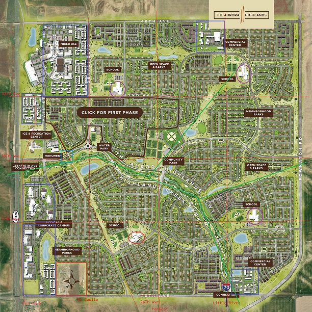
I should highlight the open space on a map.

Nobody cares about my opinion on a blog no one reads, but I will say that I am not happy with this.  There is nothing "holy" about acquiring land and putting a fence around it so it can never be used again. All the open space around Buckley is just wasted space. It is not good land.  It is ugly, with weeds.   There is a pond with algae growing on it. Yes there are a few antelope running around.  If Buckley wants a buffer zone, then they should buy it.

My biggest gripe is that I don't think Tower Road between 6th Avenue and Colfax Avenue will ever be built, because this would encroach on their precious open space.

What would happen in my dreams is to relocate Buckley Air Force base to near the Colorado Air and Space Port (formerly Front Range Airport). Spend about $10 billion on building a high tech Space Force Base that would also be used for space travel.  Then take the land, more than 1000 acres and sell it at the highest and best use.  This is very valuable land, and is worth probably $500,000 per acre.  That is $500 million.  Use that money to help build the space force base.  The days of Buckley are numbered.  Just like Lowry close and was redeveloped, the same thing will happen here.  Buckley is not going to be here in 30 years.

While I like exurban sprawl better than anyone, it is smarter to have more infill development here. This is in a major city, folks, and it is surrounded on all sides by real estate developments - housing as well as industrial.  As a result, development will be pushed farther east.  What I am saying is this open space is contributing to the problem of exurban sprawl.  Nobody should be getting an award for this.

Wow, I should send this to the Aurora Sentinel as an opinion and see if they publish it.

Tuesday, November 17, 2020

South Murphy Creek

Here is the new development planned for south of Jewell Avenue and east of Gun Club.  The official name at this point is called "Murphy Creek PA-28", but Murphy Creek South sounds better.  This map is looking east, with Jewell Avenue on the left side of the map.


This map is looking east, with Jewell Avenue on the left side of the map.


And here is what the area looks like now.  This is rotated so it is looking north.  You can see the curvy street in the middle of the map which is South Flatrock Trail.

How soon will this be built?  I can't find anything.  The developer is Meritage Homes so their website may have more information.  This hasn't been approved yet.  I would guess it will be approved in mid-2021, and construction would start in spring 2022 and it should be finished by summer 2023.  But that is just a guess.

This project could be killed by concerns over toxic water spreading north from the Lowry landfill site, which is just to the south.  But the planning documents don't mention anything about that. 

For more information see https://www.facebook.com/groups/MCDistrict3/ .  This is a private group, so you would have to join to see anything.

Tuesday, August 4, 2020

Monday, August 3, 2020

Oakwood Propaganda


This was posted to Youtube on 5/29/20 so it is very new.  It is less than 3 minutes long and it will make you feel happy and want to move there so watch it. 

One little complaint: the title says "Green Valley Ranch Aurora", whereas everyone knows that Green Valley Ranch is in Denver, and Picadilly Road is the dividing line between Denver and Aurora, so this is not actually in Green Valley Ranch but near it. 


Oakwood Homes

Oakwood Homes is building several new housing developments east of Picadilly Road near Green Valley Ranch:  Retreat Collection at the Reserve;  Horizon Collection at Green Valley Ranch / Meridian Collection at Green Valley Ranch; and Carriage House at Green Valley Ranch.  They are also developing "The Enclave at Green Valley Ranch".  Also "The American Dream" and "Fairway Villas (55+)" (made up of Bungalows and Villas at Fairway Villas) are close by. 

And don't forget Commerce City: Sterling Collection at Reunion, Meridian Collection at Reunion, and Carriage House at Reunion.  And of course Adonea, which I have mentioned before.  And if you want to go farther afield, they are also building in Erie Highlands.   These are all so new that they don't show up on Google Maps, and their website has very little information.  So there could be a whole series of articles about these, which I may or may not make.  Stay tuned.

Harmony Park


Inside this finger of land between E Alameda Avenue and Robertsdale Street is a very cool park, with a nice playground for kids and a nice walking trail around it.  The houses on Scottsburg just to the west of the park are all model homes for the new Harmony subdivision that is being built.

What is interesting is that on three sides this is surrounded by farmlands and on the 4th side to the north is vacant land ready to build homes on.  I love this park and give it an A on my list of exurban parks.

Future Walmart at Jewell and E-470

Source: https://www.loopnet.com/Listing/Jewell-Ave-E-470-Aurora-CO/10049414/

I don't know if the Walmart is planned or if this is just an example of what someone thinks could be built there.  The site marked in red is for sale for $3.7 million.  It seems kind of pricey for an awkward piece of land,  but it is still cheaper than other retail land in Aurora.  Anyways, the Walmart caught my attention.  Maybe this will be built in 20 years.

Wednesday, July 29, 2020

Aurora Places Plan


Source: https://www.auroragov.org/UserFiles/Servers/Server_1881137/File/Business%20Services/Planning/Comprehensive%20Plan/Aurora%20Places%20Plan%20Adopted.pdf

This is a fascinating plan, showing future Aurora growth.  I'm interested in the section that is mostly yellow above.  The yellow shows housing, red commercial and green is open space. The boundaries are roughly Gun Club on the west, I-70 on the north, Imboden Road on the east (although portions go all the way east to Schumaker) and Quincy Road on the south.  This is an enormous area which is about 7 miles north/south and 7 miles east/west.

I took an existing map and drew on it to show the same area:


This is kind of embarrasing.  It might be fun for a kid to do.  Anyways, you can see that the major north/south arterials are Gun Club Road, Monaghan Road (in pink) and Watkins Road.  The major east/west arterials are Sixth Avenue and Jewell.

The major commercial zones are: the northwest corner of E-470 and I-70, south of Watkins, near Jewell and Gun Club, at the the intersection of Jewell and Monaghan, and the intersection of Watkins Road and Jewell.  Basically any place those arterials mentioned above meet.  I'm not sure about 6th and Monaghan, because Sky Ranch is planning on developing at least 3 of those corners.

Anyways, we are talking about a planning area of 49 square miles.  6 of those are off-limits because of the landfill, and another one in the far southeast corner  (off limits because of possible bombs).  That leaves 42 square miles.  Of those, I think 4 are fully developed.

I don't think this will ever happen.  Truthfully, I don't think Monaghan Road will ever be built.  The only segment that currently exists is between Colfax and 6th.  I think just focus on the area west of Powhatan and north of 6th Avenue.

Urban Collection at Parkway Point by Richmond American

https://www.richmondamerican.com/colorado/denver-metro-new-homes/aurora/urban-collection-at-parkway-point

This is very close to the East Creek development.

Westminster Uplands


The Westminster Castle was built in 1892 near 83rd and Federal.  It was purchased by the Pillar of Fire church in 1920 and used as a school.    There are 150 acres of farmland north of the building.  Now the church is selling the land to a developer who plans on building "2,350 apartments, townhomes and single-family detached homes along  with office, commercial, retail, civic and recreational areas".  Construction is supposed to begin in 2021 and take 15-20 years.  I think the castle will be preserved since it is a historic landmark.  There is a farmhouse and barn on the property which I am

This still seems like it is in the early planning stages and there are no maps of the proposed development.  The neighbors want to preserve the entire area as open space, but of course they don't want to pay for it.

See: denverpost.com/2019/09/09/westminster-development-open-space-population-growth/
https://uplandscolorado.com/

Here is a current map of the area.

East Creek by Meritage

This is a map of the East Creek development on the northwest corner of Buckley and Alameda.


This is the satellite view beforehand.


East Creek refers to East Tollgate Creek that passes by the top of the property (off the map).  It is dry most of the time.  I think it runs northwest.

Tuesday, July 28, 2020

This is Aurora 2019


A promotional video from a more innocent age.

VASA Fitness for sale


Only $11 million.   This is the club as Colfax and Chambers that used to be a Kmart.  See https://www.nnnfitness.com/listings/vasa-fitness-aurora-co/   The buyer would earn $750,000/year, as long as VASA is in business.

Monday, July 27, 2020

Blaze torches 2 Aurora homes

Source: https://sentinelcolorado.com/news/metro/blaze-torches-2-aurora-homes-monday-afternoon/

Two central Aurora homes were decimated in a fire Monday [July 27] afternoon, though no serious injuries were reported, local authorities said via Twitter.  Two residences in the 500 block of Florence Street in the city’s Sunnyvale neighborhood were deemed “uninhabitable” after a blaze tore through the area around 3:45 p.m., according to tweets from Aurora Fire Rescue.

The Revel at Dearborn by Brinkman

Brinkman Construction is busily building a new housing project near 4th and Sable.  This is the only picture I can find of what it should look like:

 Source: https://brinkmanconstruction.com/portfolio/revel/

Here is what the site looked like the last time Google's spy satellite took a picture of it:

The spots on the map are from prairie dog holes.

I don't know if the project name is "Revel" or "Dearborn Apartments".  I don't know when it will be completed, but my guess is by summer 2021.

Damage to Aurora Municipal Building


The Aurora Municipal Building, which includes the courthouse and police department, was heavily damaged by violent terrorists on Saturday night (July 25).

Friday, July 24, 2020

The Heights of Westerly Creek


This is a proposed development at 2352 Dallas St, near the Stanley Marketplace.  I doubt this will every happen and the drawings are from 2016, but it is fun to dream, right?    It is sure better than what is there now, an empty lot in an industrial area.

Lowry Range Development

Read: https://www.arapahoegov.com/DocumentCenter/View/333/Lowry-Range-SubArea-Plan

This document was produced in 2007, and really nothing has happened since then.  A company named Lend Lease produced a development plan and then dropped out in 2009.  I don't think this plan is dead, just on ice for another 30 years or so.  This may happen about 2050.   This is a map of the planned development.  I circled the Urban Development Area in green.  The Future Development Area still has some possible bombs on it that will need to be cleaned up.  I included the Aurora Reservoir for reference.


And here is what it looks like today.


This is outside the Aurora city limits and could be developed without approval from Aurora.

Aerotropolis Regional Transportation Authority


I just ran across this bizarre website for the Aerotropolis Regional Transportation Authority.  I think it is bizarre because of the pretentious name and grandiose dreams.  They are planning on $174 million of transportation improvements in the above area before 2032.

In reality, I don't think any of that will ever happen except for building about 100 homes in the middle of the Aurora Highlands development.  Look at the existing map of the area, bounded by Picadilly, 56th Ave, Monaghan Road and 26th Avenue.


There is absolutely nothing there, except E-470 goes across it, and there is a small industrial site just north of 26th Avenue.  This is a huge area with 12 square miles of land, but there are no paved roads in that entire area, except for a short portion of Gun Club Road next to E-470.  And there are very few dirt roads (a short section of Powhaton Rd).

I wish them and The Aurora Highlands well, but I just don't see this happening, beyond the initial 100 homes, like I said.

Far Northeast Denver


Source: https://www.denvergov.org/content/dam/denvergov/Portals/646/documents/planning/Plans/Far_Northeast_Area_Plan/FNE_Future_Neigborhood_Context_Future_Places_maps.pdf

Far Northeast Denver is the portion of Denver including Montbello, Green Valley Ranch and the areas between, and the corridor along Tower Road connecting to Denver International Airport.  This planning area includes the former plan for 61st and Pena.

I think this map is pretty cool because it shows where future streets are planned. 

I stumbled across this when trying to find the name of the neighborhood to the southwest of GVR & Tower, served by Kipp Northeast Elementary, but I  still don't know the name of it.

Stafford Logistics Center


Source:  https://images1.cityfeet.com/d2/nPJad5k7CJn7O-ELHuj-fieuYptTGa6sjfR5ngSZFBs/document.pdf
http://www.staffordlogisticscenter.com/

Just south of Colfax Avenue, sits a huge plot of land destined to be an industrial park known as the Stafford Logistics Center.  According to the above map, this will contain 9 massive buildings.  The site has 4.4 million square fee on 350 acres.  That building 9 by itself will have 1,096,000 square feet of land, which is about 25 acres. 

This will benefit greatly from the Picadilly Road interchange.

The developer is NorthPoint Development.  Building 1 is supposed to be finished in Q1 2021.

Denver Connection


Source: https://www.denverpost.com/2016/10/21/700-new-homes-green-valley-ranch-neighborhood/

Denver Connection will include 284 single-family homes and 414 attached townhomes over the 115-acre site. Forty of those acres will be designated as open space, including a 10-acre park maintained by Denver Parks and Recreation.

Note that this article was written in 2016 and the development has now mostly been completed.  I like the small series of parks along where Laredo Street should be.

I wrote about this previously in What do you do with a problem like Chambers and Green Valley Ranch Boulevard?

My complaint about this is why does it have so much open-space.  After all, this is right next to the Pena Blvd corridor and is close to the mother-of-all-open-spaces Rocky Mountain Arsenal.  The areas marked as "Future Proposed Retail" and "Mixed-Use" have not been developed and remain vacant land.

The large oval park (intersected by another small oval park) in the bottom middle looks cool, but it hasn't been built yet.

See http://www.denverconnection.com/ for more details.  See also https://aurorainfill.blogspot.com/2017/03/the-denver-connection-and-pena-blvd.html

Painted Ridge


Mountain views, luxurious finishes, ideal location. Our intimate collection of luxury townhomes is situated on a quiet street in southeast Aurora. Conveniently located off Hampden Avenue, Painted Ridge offers residents quick access to recreation, schools, shopping and entertainment. Our community features stunning two-story townhomes with magnificent views of the Rocky Mountains to the west. ​ All of our homes feature driveways, attached garages, and either standard or walk-out basements. http://www.paintedridgeco.com/

Wednesday, July 22, 2020

Fire leaves blighted apartments

Source: https://sentinelcolorado.com/news/metro/4-units-decimated-1-dog-killed-in-aurora-townhome-fire-wednesday/

On June 17 there was a fire in a quadriplex near 17th Place and Norfolk (the nearest major cross streets are Colfax and Airport Blvd).  Four units were destroyed and no one was killed, thankfully.  However, it has been more than a month and there is a fence around the units, but they remain in their burned condition.  It may take years for them to be torn down because of debate over whether it can be repaired, coronavirus (which is the excuse for everything), insurance, city permits, possible asbestos, and demolition complexities in a crowded area.  In the meantime, it is definitely blighted.  And blight can spread and destroy housing values.  Here is a picture I took yesterday of what it looks like now.


Tuesday, July 21, 2020

Ursula Street Park at 21 Fitzsimons


The 21 Fitzsimons is bounded by Mountview Blvd on the south, 23rd Avenue on the north, Scranton St on the west and Uvalda St on the east.  It is bisected by 22nd Avenue running east and west and Ursula St running north and south.  This neighborhood is much smaller than the ones I usually define.  This is only a quarter-mile by a quarter-mile instead of a mile by a mile.

Why do I call this exurban, instead of suburban or even urban?  It seems urban because all the buildings are 4 stories, and it is near several 10-story hospitals. Well, look at this map that I drew on in Paint:


The area I enclosed in green is the same as that above.  The area enclosed in yellow is what I call "exurbia".  It is either a dirt parking lot, or vacant land or open space.  Much of it is covered in weeds or rocks or construction debris.  This exurban space surrounds the urban plot in the middle and really drains the life out of it.  You could lay out by the pool in the middle of one of the apartment buildings and forget about the wasteland around you, but anywhere else in this neighborhood you are very aware of it.  Maybe you could excuse it, thinking that it is "under construction".  But how long will this state of being "under construction" last?  And then you will just have to accept that the area will always look this way.

The real tragedy is that when the Army occupied this land, it had a beautiful well-maintained golf course on it.  But then the planners of the medical campus thought it would be a good idea to bulldoze the golf course and let weeds grow there.  And to let the clubhouse at the golf course decay to such an extent that it will have to be torn down, but that hasn't happened yet, so now it is blighted.

Another depressing element is the newly built apartment complex on the northeast corner of the 21 Fitzsimons neighborhood.  It is so new that it isn't on the above maps.  But it seems to be abandoned, maybe of victim of the coronavirus recession.  Maybe it is still under construction, but something about it seems mildly creepy and weird, with the many outside entrances, and the labels still on the glass.

Anyways, the point of this little blog post isn't the neighborhood or the surrounding wasteland, it is the park at the middle of it.  This park doesn't have a name, not that I can tell, so I will call it "Ursula Street Park".  On one map it shows up as "Donor Park", but I can't find that repeated anywhere else.
It is a nice enough park with a pleasant egg-shaped design, with a sidewalk around it and criss-crossing it.  You could maybe imagine an orchestra in the park, if it was bigger, and if there was a bandstand built and if coronavirus didn't exist.  But this is just a boring nice park that is the centerpiece of the neighborhood.  I would give it a B; however it has a big flaw.  The area south of Montview is covered in weeds, and that really detracts from the loveliness of the park.  So overall, I would give this a C in my ranking of exurban parks in Aurora.

Monday, July 6, 2020

New name for Stapleton

The Stapleton neighborhood will be renamed, because former Denver mayor Benjamin Stapleton was a member of the KKK.  So what is a better name?  There are 331 suggestions.  How would I vote?  How about Southfield, since there is already a nearby Northfield, and it starts with an S, and is about the same number of letters as Stapleton.  StanleySkyfield and Skyview are other good ones.

A list of 8 finalists will be released by August 1.

Update:  The new name is Central Park.

Side Creek Park in Louisiana Purchase


I am calling the above square mile Louisiana Purchase because it is such a clever name.  It is bound by the unfinished Mississippi Avenue on the north, Tower Road on the west, Powerline Trail and Jewell Avenue on the south, and to the east by an imaginary line where Himalaya Road should be.
This is made up of 3 sub-neighborhoods, Side Creek, which is most of the western part of the map (all west of Dunkirk); Louisiana Purchase, which is on either side of Dunkirk, including the triangle that juts out to the east; and Lexington East, which is the quadrilateral shape in the southeastern part of the map. There is a semicircle of land to the west which I think is reserved for retail, but it is undeveloped.

The park is Side Creek Park and it is surprisingly nice.  It has a walking trail that invites you to walk around it, and there are some very cool sculptures of geese.  This is very elegant and the only thing missing is a little water, so I will give it a solid B.

Friday, July 3, 2020

Willow Bend Park in The Conservatory

For my first exurban park, I will review Willow Bend Park at 20646 E Eastman Ave, in the Conservatory Neighborhood.  Here is a map of the neighborhood:


The Conservatory at the Plains is a very boring exurban community, made entirely of single family homes with tiny backyards..  It is bounded on the south by Hampden Avenue, on the west by a swath of right-of-way where Himalaya Street should be, on the north by right-of-way where Yale Avenue should be, and on the east by an imaginary line where Picadilly Road should be.  The nearest town center is at Tower and Hampden, just over a mile away.  The nearest fire station is fire station 10, a few blocks south of Tower and Hampden.

To the east is the Plains Conservation Center.  Now we could appreciate it somewhat if this was forest land, or wetland, but it is just dry prairie grass.  What is so special about this land that it has to be preserved?  There are billions of acres of land to the east that is identical.  This is prime land that is next to a major arterial and next to a superhighway (E-470).  Now this is also south of a runway at Buckley Air Force base and nobody wants to be worried about a plane crash or about the noise.  So I think that is the real reason for its existence.

The centerpiece of this neighborhood is the Aurora Frontier School.  There is a large grassy area next to the school, but it isn't open to the public, only to kids.  So the exurban park is Willow Bend Park, and here is a picture of it:


The description of Willow Bend Park is: 0.3 acres, picnic shelter, playground, access to Conservatory West Trail.  Right next to the park is open space.

There are 2 other parks in the neighborhood: Blue Grama Grass Park (1 acre), which is literally just grass next to open space, and Switchgrass Park (4.3 acres), on the northside of the map, which is a little nicer, but it isn't in the center of the community, and it is bounded by open space on the west and is close to the open space prairie on the east.

So there is my review of Willow Bend Park, the central park of the Conservatory.  I give it a D.  It has no pond, no flowers, but it does have a walking trail.  And it is an official park, which means that the city is paying to water, mow and otherwise maintain it, so it qualifies as a "folly", and is right next to open space.  So I am not impressed.  

Exurban Parks

I think the term "exurban" describes the eastern part of Aurora very well. An exurb is an area outside the typically denser inner suburban area of a metropolitan area, which has an economic and commuting connection to the metro area, low housing density, and growth. It shapes an interface between urban and rural landscapes holding an urban nature for its functional, economic and social interaction with the urban center, due to its dominant residential character. https://en.wikipedia.org/wiki/Exurb

An exurban park is in some sense, a "folly". In architecture, a folly is a building constructed primarily for decoration, but suggesting through its appearance some other purpose, or of such extravagant appearance that it transcends the range of garden ornaments usually associated with the class of buildings to which it belongs. https://en.wikipedia.org/wiki/Folly  Ok it isn't a building so it doesn't meet the strict definition of a "folly", but it was built.  It was designed and took funds to build it and it is extravagant because there is no need for it.  The builders could have left the land undeveloped.  And because of the location, there is likely open space or farmland nearby.  Why spent architecture time and money on something that only a few somewhat wealthy people get to enjoy.

But it also is part of a "commons".  The commons is the cultural and natural resources accessible to all members of a society, including natural materials such as air, water, and a habitable earth. These resources are held in common, not owned privately. Commons can also be understood as natural resources that groups of people (communities, user groups) manage for individual and collective benefit. https://en.wikipedia.org/wiki/Commons .  This is the wealth of the land held in common for the members of the land.

I will be looking at the map and identify some exurban parks.  Some characteristics:
1.  Designed.  Open space does not qualify.  And preferably has a playground, pond, flowers and walkways.  Of course it must have grass.
2.  The centerpiece of a planned neighborhood, which has a name and definite boundaries.
3.  Built since 2000.  I want recently designed parks.

I will be listing a number of these and then at the end, rank them subjectively.

=========================================
Another factor of an exurb is "wasteland" or large amounts of vacant land that will probably never be developed.  With exurban sprawl, development occurs only sporadically, with large amounts of vacant land around the developments.

Thursday, July 2, 2020

Sky Ranch

Source:  https://skyranchco.com/wp-content/uploads/2019/05/Sky-Ranch-Community-Map-Model-Directory-v1.pdf

This is just the first of 6 different neighborhoods that will make up the Sky Ranch development.

FAQs:
Why is this called Sky Ranch?  This used to be on the site of an old airfield with the same name.

What are the empty rectangular spaces to the west and south in the map?   Unknown, apparently they are owned by other landowners and not part of the development.

Are they going to pave 6th Avenue as part of this development?  Apparently the developer will pave about half of it, from the east edge up to Vandriver Way, next to the empty space to the south, but that's all.  They are relying on the city to pave the rest of it.  As a result, this is very hard to get to.  The only way in is from Colfax south to Monaghan Road. So even though this is very close to the Adonea development, there is no direct way to get there.

See also: https://aurorainfill.blogspot.com/2016/07/sky-ranch.html

Update:  The original Sky Ranch was near what is now 32nd Parkway and Himalaya, north of I-70.  There are two buildings still standing that used to be the hangars from the old Sky Ranch airfield, and there is a Sky Ranch Road in front of them.  See also http://www.airfields-freeman.com/CO/Airfields_CO_Denver_NE.htm#skyranch

There once was an East Colfax Airport, later renamed Aurora Airpark, on this land.  I guess Sky Ranch sounds better than East Colfax Airport for a housing development.

Wednesday, July 1, 2020

Transportion Plan for East Aurora


What is interesting here: 
1) This shows 4 new interchanges: Picadilly/I-70 (which I just wrote about), Harvest/I-70, 38th/E-470 and 48th/E-470.  
2) Harvest Road will be at least 4 lanes between 26th Avenue and Jewell.
3) There is another east-west street planned between Picadilly and Monaghan between I-70 and 6th Avenue.  I don't even know the name of it, maybe 13th Avenue.  Or Colfax, that would be cool.
4) Between 38th Avenue and 64th Avenue there is another north-south street planned called Tibet St.
5) Picadilly Rd will extend all the way north to Pena Blvd, but there will be no interchange at either E-470 or Pena.

For an earlier version, see https://aurorainfill.blogspot.com/2017/04/new-boulevard-map.html

Waterstone

Source: https://www.lennar.com/new-homes/colorado/denver/aurora/waterstone

Waterstone is yet another new housing development being built in Aurora Colorado just north of the Murphy Creek development.  The semicircular design is interesting.

My main complaint is that is that this doesn't connect to the neighboring development to the west.  Ada Place here should connect to Ohio Avenue to the west.  It also should connect to Exposition Avenue to the northwest.  And to the east, it should connect to the as-yet unbuilt Harvest Road.  I can't believe the city would let them build it this way.   As a result, this will be very hard to get to, with only 2 connections to Mississippi to the south.

What is cool about this is that to the north and east this is bordered by the shallow Coal Creek.  And there are herds of deer that live there.

Harmony

Source: https://hereinharmony.com/wp-content/uploads/2020/05/HAR-005-Land-Plan.pdf

This is directly to the east of Adonea.  The main development area is bound by 6th Avenue to the north, Powhaton Rd to the west, Exposition Avenue to the south and Monaghan Road to the east.
Sky Ranch, another development, is being built near Monaghan Road north of 6th Avenue, but 6th Avenue hasn't been built yet east of Powhaton.

Update:  This development apparently was previously called Sun Meadow (the area north of 1st Avenue), and Starfall (the area between 1st Avenue and Alameda Avenue.  On some real estate websites, there is mention of the Starfall Horizon neighborhood.  I guess Horizon sounds better.  I'm not sure when the name was changed.

Painted Prairie

Source: https://www.auroratv.org/video/aurora-2019

This is bounded by 64th Avenue on the north, Himalaya Rd/Ireland St on the west 56th Avenue on the south, and Picadilly St on the east.  I really like the grid made by 60th Avenue bisecting it west to east and Liverpool St (or is it Lisbon) north-to-south.  It has a large park in the middle of the eastern half. This will be a very nice development.

See also: https://aurorainfill.blogspot.com/2016/07/painted-prairie.html

Adonea

Source: https://www.youtube.com/watch?v=pLUgOcLOiMQ

Another subdivision under development.  Adonea is just the eastern part of the map, with Little River St as the dividing line.  The western part of the map is called "Traditions".

Prosper Subdivision No. 1

Source: https://www.arapahoegov.com/DocumentCenter/View/3950/Prosper-PP-Filing-1?bidId=

This is the first phase of Prosper, located south of Watkins in unincorporated Arapahoe County.  The preliminary plat was approved on August 15, 2017, so nothing has happened on this for 3 years.

The Board of Directors for Prosper Metropolitan District No. 1 met on November 25, 2019 and produced a budget with $0 expenditures in 2020.  The district also has no debt, thankfully.  See https://cdola.colorado.gov/local-government and search for:  Prosper Metropolitan District No. 1

The oval in the middle seems to be a park.

See also https://aurorainfill.blogspot.com/2017/03/aurora-will-not-prosper.html

I think this project is dead, especially with today's economic climate.  The project owner is Prosper Farms Investments LLC and the developer is Vogel & Associates and neither one seems to have deep pockets.  This is just a pipe dream.  Maybe in about 20 years it could be revived, but at that point they should just start from scratch on the plans.

I think they should turn it into a llama and alpaca farm.  They could charge admission to visitors, and they could sell the fur.

Tuesday, June 30, 2020

Picadilly Road Interchange

Source: https://www.auroragov.org/UserFiles/Servers/Server_1881137/File/Business%20Services/Planning/170%20Picadilly/04302019_Picadilly_Alt03_Map_01Reduced.pdf

This is a fascinating map.  Check out the original.  Construction will start in Spring 2022 and finish by Fall 2023.  The U.S. Dept of Transportation has already allocated $25 million towards construction of this.

Colfax Avenue will end at Picadilly.  Currently, westbound traffic on I-70 exits to the left on to Colfax.  In the new alignment, this exit will be closed and traffic will exit at Picadilly.  Also, the exit at Colfax/E-470/Gun Club will be totally redesigned.

Note the huge Amazon Fulfillment Center, which will be a heavy user of this interchange.

Also check out the cool Diverging Diamond simulation video:
https://www.auroragov.org/UserFiles/Servers/Server_1881137/Media/Picadilly%20Diverging%20Diamond%20for%20Website.mp4

Aurora Public Schools attendance area for Harmony P8

Source: https://aurorak12.org/2019/12/18/aps-board-of-education-makes-decision-on-school-boundary-changes/

I find this map interesting, not because I care about school district boundaries, but because it shows lots of interesting details.  For example, it shows Murphy Creek expanding to the south, and it shows the subdivisions of Traditions, Adonea, Harmony and Sky Ranch.  It also shows Horizon Uptown as if something will be built there (but which probably won't ever happen).  And it also shows Aurora Highlands and an expansion of it to the east.

I pity the fools who live in Singletree and have to bus their kids to Harmony P8.   Hopefully, a new school will be built closer to where they live.

In case it isn't clear, this is a humongous map, about 8 miles wide and 12 miles tall.

Saturday, June 27, 2020

The Aurora Highlands


The Aurora Highlands is a massive master-plan project under construction right now that will take about 30 years to fully develop. I have had a little time to review it and these are my thoughts.

1.  The name - it sucks.  It sounds vaguely Scottish and makes you think of rolling hills and sheep. It doesn't fit this project.  The first rule of naming something is to make it somewhat unique.  The name "Highlands" is very common.  Remember Highlands Ranch?

2.  The lack of a grid.  I like grids, as in the street pattern for New York City.  Denver and Aurora itself have a pretty good grid.  This plan was made by an anti-gridder.  I would make North-South streets at De Gaulle, Harvest and Little River, and East-West avenues at 32nd, 38th and 44th, and draw some inspiration from Northwest Denver.  Harvest is a natural place to put a grand boulevard but there is only a bike path here.  There is no easy way to go east to west in this plan and north to south is even worse.  (By the way, the bottom avenue is labeled 28th Avenue, but it should be 26th Avenue.  The architect obviously doesn't understand the anomalies of the Denver street grid).  One more thing - the main north-south frontage road currently on the property which is Gun Club Road will be eliminated and replaced with "Main Street".  How unoriginal.  And this isn't a main street that anyone would walk along because it doesn't go anywhere and has nothing interesting on it like maybe a shoppe.

3.  Natural contours of the land.  There are some small creeks that run through the area, and the architect follows those and I like that.  Notice that there is kind of a greenway or "river" (which I put in quotes because I think it is dry most of the year) which separates the southwest part from the rest of it.  There are only 3 bridges that cross this area.  

Note that the southeast part of the river doesn't even cross 26th Avenue.  Maybe I am reading the map wrong but it looks like you are going to tear up an existing creekbed and pave it with a street and parking lot.  This was one feature of the plan I liked but you need to finish the job.

4.  Lack of a heart.  There are lots of parks on here and quite a few artificial ponds (at least 10).  But there is no central plaza or community center.  There is a water park right behind the monument and that would be a natural place for a plaza.  Or maybe right in the middle where I see at least 7 soccer fields and 4 baseball fields. There is lots of commercial space on the plan.  How about making a small downtown area similar to the Southlands Mall, but smaller?  And I don't see any spaces for police stations or fire stations, a la Simcity.  What about churches, or a gas station (at least a 7-11) or a supermarket?  There is a King Soopers at Green Valley Ranch and Tower, but that is a little drive.  What about a pharmacy or ice cream store?  Where is the Wendy's?  This is a very sterile boring environment that perpetuates some of the worst stereotypes of suburbia.

5.  Overemphasis of the ley line.  There is a ley line on here, presumably from an underground gas line.  I don't like ley lines and find them kind of weird and spooky.  Yea you can't build right on top of a gas line but you don't need to design your street grid around it.  You know streets are allowed to cross the ley line to connect your sub-neighborhoods, but here it is used to divide.  And since we hate grids, how about putting a road on the ley line?  Well part of it has a road, but most of it is just a useless bike path.

6.  Too many parks.  Count how many soccer fields are on this map.  I see 15 although one of them may be a tennis court.  What about baseball fields?  I count 12.  I have already mentioned the ponds.  What about oval green grass areas?  Maybe these are just filler but I count 9.  Are these going to require extra watering and mowing?  I don't like the concept at all but like I said, maybe these are just filler.  

7.  Dead-end neighborhoods.  Not only does the planner hate grids, he also likes to make it very difficult to get out of sub-neighborhoods.  Look at the sub-neighborhood in the northwest section next to the school, right next to Denali Blvd - it doesn't connect.  And on the east side, check out how many streets connect to Powhaton, which will be a 4-line boulevard - only two. 

8.  One more thing while I am criticizing this.  What's up with the ugly clock?  It would be halfway cool if you could climb stairs to lookout from the top, like the Stapleton control tower.  If you are going to build an analog clock make it like Big Ben with chimes every half hour.  But no, this is an ugly clock that serves no purpose.

In conclusion, the project planners have probably spent millions on this design and there will be 30,000 people living here when it is built out, but it is a flawed design.  Unless you like soccer.

Anomalies in the Denver street grid

In the Denver street grid, usually east-west streets are 16 blocks to the mile, and north-south streets have 8 blocks to the mile.

For example, Wadsworth Blvd is 7600 W, and Sheridan is 5200 W.  This is 24 blocks away, so you can tell that it is 1.5 miles away.  Now 1 mile east of Sheridan is Lowell Blvd, which is 3600 W.  Note however, that it is 1/2 mile from Lowell to Federal Blvd, but Federal is 3000 W.  And Federal is 1/2 mile from Zuni, but Zuni is 2400 W.  So between Zuni and Lowell, a distance of 1 mile, there are actually 24 blocks to the mile, but everywhere else it is 16 blocks to the mile.

Now a similar anomaly exists with the north-south numbering.  Usually there are east-west streets every 1/2 mile, to match the quarter-section lines and these are 4 blocks apart.  For example, from 48th Avenue to 44th Avenue is 1/2 mile.  However, 1/2 mile south of 44th Avenue is 38th Avenue (whereas you would expect it to be 40th Avenue).  And 1/2 mile south of 38th is 32nd Avenue.  And then you have 26th and 20th. 

Now a further anomaly exists.  20th Avenue is 1/2 mile north of Colfax Ave, which is 1500 N.  And 1/2 mile south of Colfax is 10th Avenue.  1/2 mile further south is 6th Avenue and then 1st Avenue.  Between 1st and Alameda (300 S) is 4 blocks. 

So we can state the rule:  In the Denver street grid, north-south streets usually have 8 blocks to the mile. 1. However, between 1st Avenue and 6th Avenue, there are 10 blocks to the mile.  2. Between 6th Avenue and 10th Avenue, there are 8 blocks to the mile.  3. Between 10th Avenue and 20th Avenue, there are 10 blocks to the mile.  4.  Between 20th Avenue and 44th Avenue, there are 12 blocks to the mile.

So these are all east-west streets, spaced 1/2 mile apart.
Exposition Ave
Alameda Avenue
1st Ave
6th Ave
10th Ave
Colfax Ave
20th Ave
26th Avenue
32nd Avenue
38th Avenue
44th Avenue
48th Avenue
52nd Avenue