The Aurora Highlands is a massive master-plan project under construction right now that will take about 30 years to fully develop. I have had a little time to review it and these are my thoughts.
1. The name -
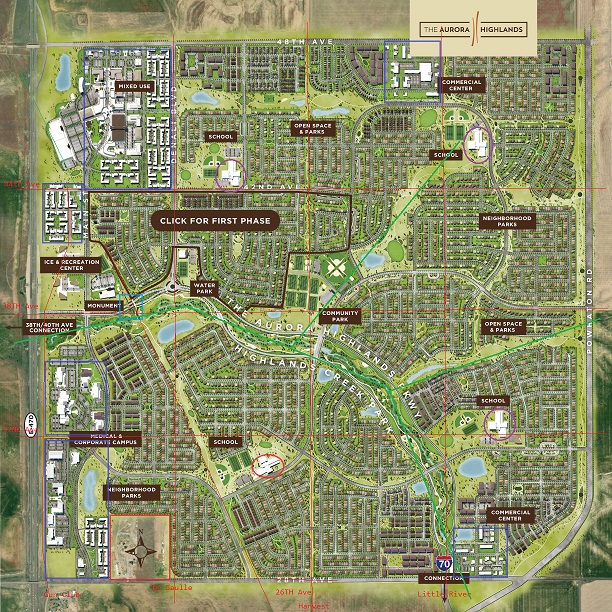
it sucks. It sounds vaguely Scottish and makes you think of rolling hills and sheep. It doesn't fit this project. The first rule of naming something is to make it somewhat unique. The name "Highlands" is very common. Remember Highlands Ranch?
2. The lack of a grid. I like grids, as in the street pattern for New York City. Denver and Aurora itself have a pretty good grid. This plan was made by an anti-gridder. I would make North-South streets at De Gaulle, Harvest and Little River, and East-West avenues at 32nd, 38th and 44th, and draw some inspiration from Northwest Denver. Harvest is a natural place to put a grand boulevard but there is only a bike path here. There is no easy way to go east to west in this plan and north to south is even worse. (By the way, the bottom avenue is labeled 28th Avenue, but it should be 26th Avenue. The architect obviously doesn't understand the anomalies of the Denver street grid). One more thing - the main north-south frontage road currently on the property which is Gun Club Road will be eliminated and replaced with "Main Street". How unoriginal. And this isn't a main street that anyone would walk along because it doesn't go anywhere and has nothing interesting on it like maybe a shoppe.
3. Natural contours of the land. There are some small creeks that run through the area, and the architect follows those and I like that. Notice that there is kind of a greenway or "river" (which I put in quotes because I think it is dry most of the year) which separates the southwest part from the rest of it. There are only 3 bridges that cross this area.
Note that the southeast part of the river doesn't even cross 26th Avenue. Maybe I am reading the map wrong but it looks like you are going to tear up an existing creekbed and pave it with a street and parking lot. This was one feature of the plan I liked but you need to finish the job.
4. Lack of a heart. There are lots of parks on here and quite a few artificial ponds (at least 10). But there is no central plaza or community center. There is a water park right behind the monument and that would be a natural place for a plaza. Or maybe right in the middle where I see at least 7 soccer fields and 4 baseball fields. There is lots of commercial space on the plan. How about making a small downtown area similar to the Southlands Mall, but smaller? And I don't see any spaces for police stations or fire stations, a la Simcity. What about churches, or a gas station (at least a 7-11) or a supermarket? There is a King Soopers at Green Valley Ranch and Tower, but that is a little drive. What about a pharmacy or ice cream store? Where is the Wendy's? This is a very sterile boring environment that perpetuates some of the worst stereotypes of suburbia.
5. Overemphasis of the ley line. There is a ley line on here, presumably from an underground gas line. I don't like ley lines and find them kind of weird and spooky. Yea you can't build right on top of a gas line but you don't need to design your street grid around it. You know streets are allowed to cross the ley line to connect your sub-neighborhoods, but here it is used to divide. And since we hate grids, how about putting a road on the ley line? Well part of it has a road, but most of it is just a useless bike path.
6. Too many parks. Count how many soccer fields are on this map. I see 15 although one of them may be a tennis court. What about baseball fields? I count 12. I have already mentioned the ponds. What about oval green grass areas? Maybe these are just filler but I count 9. Are these going to require extra watering and mowing? I don't like the concept at all but like I said, maybe these are just filler.
7. Dead-end neighborhoods. Not only does the planner hate grids, he also likes to make it very difficult to get out of sub-neighborhoods. Look at the sub-neighborhood in the northwest section next to the school, right next to Denali Blvd - it doesn't connect. And on the east side, check out how many streets connect to Powhaton, which will be a 4-line boulevard - only two.
8. One more thing while I am criticizing this. What's up with the ugly clock? It would be halfway cool if you could climb stairs to lookout from the top, like the Stapleton control tower. If you are going to build an analog clock make it like Big Ben with chimes every half hour. But no, this is an ugly clock that serves no purpose.
In conclusion, the project planners have probably spent millions on this design and there will be 30,000 people living here when it is built out, but it is a flawed design. Unless you like soccer.