Here is a list I am making for fun, and having 10 entries makes it more interesting. I don't believe in ghosts but this might give you some chills.
1. Fairmount Cemetery. This is actually in Denver, but it is close by, at Quebec and Alameda. This has to be one of the coolest/creepiest cemeteries anywhere outside of New Orleans. This has numerous above-ground mausoleums. A search on Google images brings up lots of spooky images.
2. Third Bridge. This is connected with multiple deaths, such as a massacre of a ranch family by Indians in the 1860s (which led to the Sand Creek Massacre), an unsolved murder, and a car accident killing two teens. (See http://www.imfromdenver.com/third-bridge-in-aurora-colorado/). There are also some Youtube videos of apparitions.
3. Richthofen Castle and Molkerei Tuberculosis Clinic. This is also in Denver, but close by. This would be a great scene for a movie. The castle was owned by real German royalty, the Von Richtofen family which included the Red Baron. The Molkerei/Molkery later became an insane asylum.
4. Haunted 7-Eleven. A 7-Eleven on Smoky Hill Road was supposedly built on a old indian graveyard. See http://www.imfromdenver.com/most-people-in-colorado-think-this-7-11-is-seriously-haunted/
5. Building 500, Anschutz Medical Center/Fitzsimons. The old Fitzsimons hospital, which today has administrative offices, is supposedly haunted with the ghosts of military personnel. Also, some of the old military buildings may be haunted. See http://coloradoghosts.blogspot.com/2009/10/fitzsimons-army-medical-center.html
6. Rocky Mountain Arsenal Army Headquarters. I have written about this before, and the whole setting is surreal. Abandoned vehicles, weeds, deer hiding in the shadows, nuclear waste, etc. The view from Rattlesnake Hill is impressive. The whole area gives off a "Cold War" vibe.
7, Parklane Swimming Pool. Someone supposedly saw an old woman in a black dress with long white hair standing next to a slide. See http://www.hauntedplaces.org/item/parklane-swimming-pool/
8. Bicentennial Park. I have written about this before. There was an old putt-putt golf course here which has been removed because of a fire. There is an Army National Guard base across the street with lots of camouflage vehicles.
9. Utility shed at First Creek Park. In First Creek Park, on old Buckley Road, about a mile north of 56th Avenue, next to Pena Boulevard, sits an old abandoned utility shed, with stairs leading to the basement. Hopefully, no one is hiding there. Near to this is the Rocky Mountain Arsenal fence, with holes in it where some one could climb through.
10. Mount Nebo Cemetary, Aurora. This is more of a curiosity rather than being creepy. Two ley lines intersect in the west end of the cemetery. There is one to the northeast which follows the property line of the King's Inn motel, and another ley line to the southeast which follows a fence line and property line right down to the intersection of 6th & Peoria. The lines predate the cemetery, which was built in 1902.
Sunday, April 30, 2017
Airport Blvd & Colfax
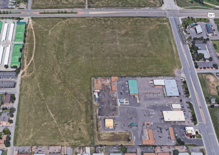
This is a very large piece of land on the southwest corner of Airport Blvd & Colfax. This would be perfect for residential, with some retail. At least it doesn't have a chain-link fence around it, like a couple of other large pieces of undeveloped land.
See also: Trolley Station
Meritage Highline

Soure: https://www.meritagehomes.com/assets/resources/denver-co/highline/HL-WebSitePlanFlyer.jpg
This is a very nice infill project at Dayton & Mississippi, with homes starting at $450k. One interesting thing is a "wilderness area" just below lot #31 on the map. It's good that this blank spot on the map is finally filled in. I will highlight some more areas that need projects like this.
See: https://www.meritagehomes.com/search/denver-co/highline/
Friday, April 28, 2017
Coast Guard in Aurora
Did you know there is an active Coast Guard unit stationed in Aurora, Colorado at Buckley AFB?
On Buckley Air Force Base outside of Denver is the Coast Guard Cryptologic Unit Colorado; one of four cryptologic units in the Coast Guard. The commanding officer, Lt. Cmdr. Logan Medica, leads the 18 member unit conducting technical training, analysis and reporting of the maritime domain in support of tactical and operational fleet commands, the Coast Guard Intelligence enterprise, combatant commanders and national policymakers.
http://coastguard.dodlive.mil/2013/05/the-coast-guard-in-colorado/
What happened to Project Keystone?
In 2009, there was news that a facility for processing national intelligence would be built in Aurora.
A Virginia company is developing a 350,000-square-foot office building on 64 acres in Aurora for the federal government. The Peterson Cos. is expected to break ground in March on Project Keystone, which will be occupied by the Aerospace Data Facility Colorado, the largest tenant at Buckley Air Force Base. “We’re out of space at our facility,” said Sharlene Fairbanks-Kyte, public- affairs officer for the agency. “Project Keystone is to augment ADF Colorado.” The site within Gateway Park is bounded by North Walden Street, East 40th Avenue and North Salida Street. The Peterson Cos. purchased the ground from the Pauls Corp. Under an agreement reached in April, Peterson will lease the building to the Office of Director of National Intelligence. The National Reconnaissance Office will act as the executive agent for the project, which will be occupied by ADF Colorado.
http://www.denverpost.com/2009/09/10/aurora-to-get-a-new-federal-facility/
This was basically an extension of Buckley Air Force Base. This project was obviously cancelled but I can't find out any more information about what happened. There was a whole environmental assessment done called "Construction and Operation of Project Keystone, Denver: Environmental Assessment", which is available for free in Google Books.
Envision East Arapahoe
Envision East Arapahoe 3D Scenarios from City of Boulder on Vimeo.
See also: https://www-static.bouldercolorado.gov/docs/2_24_Presentation_-_Envision_East_Arapahoe-1-201507100910.pdf
http://colorado.uli.org/building-healthy-places/citys-east-edge-due-boulder-junction-style-makeover/
Boulder is trying to make an area that is filled with office and industrial parks and make it just a little bit more liveable.
Thursday, April 27, 2017
Parkside @ City Centre

This is a great project at Sable & Alameda with 38,000 of retail and office space. It is supposed to open in 4Q 2017. To make it even nicer, behind it is a lake. Light rail does run by the project, but the nearest stop is a couple of blocks south. Access to the site will be a little problem as there will basically be only one way in and out - on Sable.
Now if they could only build something similar right across the street, which remains hideous open space.
See also: http://aurorainfill.blogspot.com/2016/07/new-alameda-center.html
Tuesday, April 25, 2017
Dinosaurs battle car dealerships in the Dakota Hogback

Source: http://www.westword.com/news/jeffco-battles-over-proposed-car-dealerships-next-to-dino-ridge-8672438
There are two related items from the same area that I want to write about. First, the proposed development of the area around C-470 and Alameda Parkway, which the Westword article explains very well.
Second, the failed Mt. Carbon development just southeast of that intersection. In the early 1980s, there was a proposed development in which more than $100 million was invested with not much to show for it. It was repossessed by an S&L, which failed, and then the Resolution Trust Corp took control, but was unable to sell it. It was then inherited by the FDIC, which couldn't sell it. The city of Lakewood refused to buy it for open space. The metropolitan district went into bankruptcy and shed some of its debt. In about 2005, a new development, called Springfield Green was planned for the area. The neighbors wanted the area for open space and raised massive opposition to the project so it stalled again.
The project now is called "Rooney Valley". It consists of 2,200 acres of land in Lakewood, Morrison and unincorporated Jefferson County. The promoters hope to build about 3000 housing units and almost 2 million square feet of retail, commercial, and light industrial space. This project deserves more complete coverage and I will probably write more about it.
Monday, April 24, 2017
Bye Bye Lone Star

All the Lone Star Steakhouse & Saloons in Colorado closed in January 2017. This is a picture of the one that was at 6th & Simms in Lakewood. I think there were 7 in the Denver area at one point - in addition to the Lakewood one, Lone Stars in Golden, Arvada, Aurora, Thornton, Littleton and Brighton closed (some of these in 2015). Plus one in Loveland.
The one in Aurora was at 3055 S Parker Road, Suite 103. There is a Touchstone Imaging there now.
Condo Project Fail

This is a view of a failed condo development near Sable and Tennessee. Construction started on the project in 2005, at least laying out the streets, but it was never finished, and has sat abandoned for 12 years. There also was graffiti on the back wall, but I think it has been removed now.
Century is responsible for an unfinished condo project it started in 2005 at East Tennessee Avenue and Sable Boulevard where residents have long complained about it being an “eyesore” and a dumping ground. “We’re perplexed why the city would allow them to screw up another neighborhood when they still have collateral damage at Tennessee and Sable,” At a Jan. 27 [2016] Aurora Planning and Zoning Commission meeting for the project, Century spokeswoman Lisa Albers said the economic downturn prevented Century from completing the East Tennessee Avenue and Sable Boulevard condos. Albers said Century took over ownership of several of those condo units during the recession to keep the site’s HOA funded, and that Century is now being proactive about removing items dumped near the units.
http://www.aurorasentinel.com/news/revised-plan-century-housing-still-danbury-shamrock-neighbors-upset/
How about radically redesigning the area. Put a small plaza with a fountain in the middle, and surround it with 3 story buildings that have retail on the bottom and apartments with balconies on the top 2 floors. The whole area is pretty dense with both retail and condos. And its not that far, about 4 blocks, from the mall light rail station.
Now that I think about it, this is one of the best candidates for an infill project anywhere in the city. How about have a design competition.
And while I am at it, how about making Sable Boulevard from Iliff to 6th Avenue a main street? And there is another failed development near 2nd & Sable, that could be redeveloped in a similar fashion.
Saturday, April 22, 2017
May they rust in peace
A short video with still of rusted old cars with a weird soundtrack. From Murphy Creek, Aurora.
What do you do with a problem like Chambers and Green Valley Ranch Boulevard?

I think this is about a mile in length and a quarter-mile high, or about 160 acres. Why hasn't it been developed yet?
It would be perfect for single-family homes. It is too far away from light-rail for a high density development.

Friday, April 21, 2017
Gartrell Road Fail

Gartrell Road is a brand new road just north of E-470. There have already been two newly opened business close there for lack of business.
There was a Walgreens at 7510 S Gartrell Road (shown above) which is now closed. Also a 1st Bank was opened at 7460 S Gartrell Road which is now closed. That is sad that newly opened businesses in newly developed have failed.
West Bijou Creek

West Bijou Creek is a 7,960 acre "campus" located south of Strasburg. Part of the land is in Arapahoe county and part of it is in Elbert county. The red lines on the above map are roads that will be built. I don't think West Bijou Creek is nearly as wide as it appears on the above map. I think it is mostly dry. The map must show the streambed.
There are also other conservation easements nearby. The West Bijou Creek Conservation Easement is a 1,363 acre working farm and the easement is owned by Arapahoe County Open Space and the Bradbury Bijou Creek Ranch which is 2,800 acres. There is also the Middle Bijou Creek Conservation Easement, which is 12,578 acres. "The Middle Bijou conservation easement is the largest easement in Arapahoe and Elbert Counties and is the largest easement ever funded in the United States".
What is interesting about the area is the KT boundary, which runs through the site.
The KT Boundary is a geologic layer found in places all over the world, but Johnson calls the example in the Bijou site “one of the best examples of the KT boundary known in the world.” The boundary is the result of a huge asteroid hitting Earth 66 million years ago. “My finger is sitting on a layer that was at the surface of Colorado the day the asteroid struck Mexico. At the end of the day, it was particularly bad day on planet Earth … and when the smoke cleared some months later, all the big animals had gone extinct,” Johnson said. Just a short distance away, in the soft rock of an outcrop, Johnson showed Whitehead evidence of what the world looked like after the dinosaurs disappeared. “This hill is made of fossil leaves. There are literally tens of millions of fossil leaves in this one outcrop and as a result a place like this is fabulous for study about what happened to the world after the asteroid struck,” Johnson said. “We can count the fossils and built a real understanding about what the forest looked like here. “Right now it’s shortgrass prairie, but 66 million years ago it was a subtropical forest and you would have found things like crocodiles and turtles and snakes. Imagine yourself more in Costa Rica than Colorado.”
--http://denver.cbslocal.com/2011/05/07/many-plains-surprises-to-be-found-in-bijou-valley/
Tuesday, April 18, 2017
Second Creek Raceway
Second Creek Raceway was a racetrack near 88th & Buckley. It was shut down about 2005 but the track is still driveable, as shown by the above video.
I don't know why it was shut. The whole area around it is just empty fields. Yes to the north there are some housing developments, but to the west is the Arsenal, to the east about 5 miles is DIA (but there is nothing but empty fields in between), and to the south (again about 5 miles) there is nothing until you get past Green Valley Ranch Rd (48th Avenue).
This has to be one of the most desolate places anywhere that is actually within city limits (in this case I think it is Commerce City), and has major traffic running nearby - E-470 and Tower Road.
Emil-Lene's Sirloin House

This is the now-closed Emil-Lene's Sirloin House at 16900 (or 16000) Smith Road. It is right next to the Star K Ranch open space (about which much more needs to be written). It is very hard to find (hint: take Laredo south of Smith Road) and you would have to know it is there. That's probably why it closed. It would be nice if another restaurant would open there.
Update 4/30/2017: The building has now been torn down and it is just vacant land.
Rocky Mountain Arsenal Army Headquarters

This is a screenshot of a tilted satellite view from Google earth of the old Army Headquarters at the Rocky Mountain Arsenal. The road at the bottom of the screen is 72nd Avenue.
This is one of the creepiest places in the "Aurora area". The view above doesn't look that bad. But consider that it is completely abandoned, and the view is somewhat sanitized. There are weeds everywhere. This is a flagpole in the circle at the left third part of the picture, but no flag flies. There are lots of abandoned vehicles around, and deer walking around. There are "guards", really just a forest ranger driving around a pickup truck who might ask you questions if he sees you.
Nearby is Rattlesnake Hill, which is worth a climb, to look through the binoculars. Also to the east of this is a large fenced area topped with barbed wire. Behind the fence is some of the most radioactive land on the planet. It is owned by the US Army and signs say something like "Property of the US Army. Trespassers will be shot on sight." The gate to this area is open and unlocked.
This could easily be a setting in a video game, or in a movie.
Richthofen Castle

Source: Google Maps, at 7020 E 12th Avenue, Denver, CO
This is the entrance to the Richthofen Castle. You can search for pictures of the castle, but this is what you see from the street level, which is what us peasants see. This is technically in Denver, but before it was annexed (in 1903), it was in the town of Montclair. It was built in 1887, before the silver bust of 1893.
I am thinking of doing a series on spooky places in the "Aurora area", and this definitely would be in the top ten.
Abandoned Office Depot

This is a closed Office Depot at 3511 N Salida Ct. It is near a very busy Walmart, Home Depot, and Best Buy. But it is also near a lot of vacant land. It had only been there a few years. Another big box store bites the dust. It may be empty for a long time.
The House in the Woods

There is an art exhibit of 21 masterworks from the Morton and Tobia Mower Collection at the Fulginiti Pavilion on the Anschutz campus. It includes works from Monet, Renoir, Rodin, Picasso and Pissarro. It will be there through May 24. The above picture is my favorite from the collection.
See: http://www.cuanschutztoday.org/masterworks-exhibition-at-cu-anschutz-showcases-masterpieces-by-impressionists-picasso-and-rodin/
Closed US Bank at Iliff and Parker

This is a former US Bank at Iliff and Parker. There is a new replacement US Bank branch just a couple of blocks away at 2361 S Parker Rd.
This whole area seems kind of depressed and I have no idea why because it has very heavy traffic.
Closed Safeway in Thornton

Here is a closed Safeway at 3904 E. 120th Ave in Thornton. It closed in June 2016.
Closed Safeway in Broomfield

Yet another closed Safeway at 6775 W 120th Avenue in Broomfield. This closed in August 2014.
Thursday, April 13, 2017
Kiowa-Bennett Road

With the indirect connection to Kiowa‐Bennett Road south of I‐70 which connects to SH 86 at Kiowa, and south of Kiowa along Elbert Road to US 24, a 75‐mile north‐south roadway corridor exists. This is the only north‐south roadway corridor east of the Denver metro area until SH 71 at Limon, approximately 50 miles east of Bennett
If SH-79 was extended about 30 miles north, it could meet up with US-34. This corridor would then connect Colorado Springs with Greeley.
The locations of Denver International Airport and Front Range Airport limit north‐south arterial continuity east of E‐470 until Kiowa‐Bennett Road, which provides north‐south continuity through Arapahoe County. As residential and commercial growth continues along the Front Range, Kiowa‐ Bennett Road will increasingly become a popular north‐south alternative to I‐25 and E‐470.
Front Range Toll Road
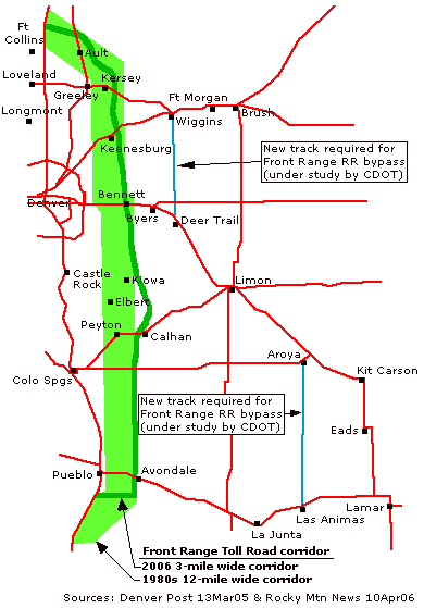
Source: http://www.mesalek.com/colo/other.html
This project (also called the Prairie Falcon Parkway Express) is totally dead now. It was a really good, futuristic idea, except people were freaking out about the developer grabbing hundreds of thousands of acres of land by eminent domain.
Prairie Meadows Park

Source: http://denverurbanreview.com/wp-content/uploads/2015/03/Stepleton.landscapes.jpg
“The design of the newest neighborhoods at Stapleton has been a very thoughtful effort to intersect urban living with the beauty of the high plains,” says Heidi Majerik, Director of Development at Forest City Stapleton, Inc. “There is respite in the peace and serenity that is inherent to the prairie while the urban form and park design provides interconnectedness not only with the environment but also with one another.”
http://denverurbanreview.com/2015/03/native-prairie-incorporated-into-new-stapleton-parks/
Monday, April 10, 2017
19th Street Interchange in Golden

Source: http://www.getthefactsgolden.org/goldens-plan/
This is a drawing of the 19th Street / US-6 interchange in Golden.
Sunday, April 9, 2017
Rant: A line FAIL

Source: http://www.westword.com/news/ten-problems-with-rtds-trains-8276488
The A line from downtown Denver to the airport encountered a problem that no one in the world has ever encountered before - the train tracks must cross busy streets. Railroads have been around 200 years but they have never before had to cross highways! (Sarcasm) Because of this unique problem, they invented a unique solution called "positive train control". This involves sensors on the train sending signals to a satellite 23000 miles overhead, which then sends them to a network operation center, which then sends a radio signal to a crossing arm to close. The problem is - it doesn't work.
So they have to have 2 crossing guards each at all 10 stops along the line, 24 hours per day to stand in front of the trains when they cross. And they sometimes have off-duty cops posted at the crossings as well.
How about putting sensors in the tracks that will detect when the train approaches and have then have them connected via wire to the crossing arms? Naw, that's too simple. Instead we want to use GPS, satellites, and wireless internet and all the latest technology.
Who is to blame for this mess? Nobody - it's certainly not RTD's fault, they had nothing to do with it (sarcasm). At least they aren't accepting any. Instead, they keep asking waivers from the Federal Railroad Administration. Maybe it is the contractors fault, or Congress's, for mandating the flawed technology.
See also: Ten Problems with RTD's Trains.
=============
Update: RTD spends $6 million per year at these intersections - $4.3 million for police and $1.5 million for crossing guards.
http://www.denverpost.com/2017/04/09/denver-airport-train-one-year-in/
Saturday, April 8, 2017
Reunion
Reunion is a 3,200 acre master-planned community in Commerce City, around Tower & 104th.
Website: http://reunionco.com
Proposed housing development near Hudson
Back in 2008, before everything crashed, there was talk of a massive housing development to be built north of I-76 between Hudson and Keenesburg:
By the year 2030, developers hope 23,000 more people will call northern Colorado home. The proposed development, which would have more than 9,000 homes, would be located near the intersection of Weld roads 22 and 49, north of Hudson and Keenesburg. Along with the homes, developers have planned nine new schools in the Weld RE-3J school district at the 5,073-acre site, as well as community parks and commercial retail.
http://www.greeleytribune.com/news/local/large-development-proposed-near-hudson-could-bring-23000-people/
It sounded like in 2008 that this was going forward. The financing was lined up, they had a water supply, and it was approved. But I haven't seen any mention of this since, not even to say it was canceled. It just went down the memory hole.
==============
Update: There is mention of this in a 2014 article:
But Parko [Tom Parko, Weld County planning director] said planners did set aside three areas in unincorporated weld for urbanization. They are the I-25 corridor, the area north of Colo. 7 between Dacono and Fort Lupton, and the Pioneer area near Keenesburg.
http://www.greeleytribune.com/news/local/with-growth-happening-fast-in-weld-county-small-towns-face-many-challenges/
So it could happen in about 20 years.
Friday, April 7, 2017
Personal Rapid Transit

The future that could have been. In the early 1970s, there was a proposal to build a personal rapid transit network in Denver.
What if, instead of light rail cars clanging alongside downtown traffic, Denver's trains burrowed underground? Or if, instead of trains, Denver had a network of tracks elevated on stilts throughout the city that flung personal pods from neighborhood to neighborhood like a kid's slot car racetrack? Unlike buses and trains, these pods could carry no more than 20 people at a time. They would have shuttled you directly to one of 40 or so stations, without stopping, along a 98-mile network high above Colorado Boulevard, Colfax Avenue, Sheridan Boulevard, Santa Fe Drive, Hampden Avenue, I-25, U.S. 36 and other corridors. Automated and driverless, many thought the system would have been an alluring technological coup for Denver at the time.
http://www.confluence-denver.com/features/denver_transit_history_011817.aspx
I wonder how these compare to self-driving cars? Or to an elevated bus system.
Dry Creek

What is it? Dry Creek is a "mostly residential 2,100 acre super development in the southernmost part of the county, a northern sibling to Adam’s County’s Todd Creek Village Metropolitan District. Located equidistantly between Brighton, Fort Lupton and Dacono and a short mile west of Wattenberg, Dry Creek, named for the stream running through some of the land, has the potential for up to 6,600 residential units. The population on the parcel, an area one-third the size of Fort Lupton and half the size of Commerce City’s Reunion, could exceed both, maxing out at 20,000."
--http://www.thebrightonblade.com/content/massive-weld-development-passes-first-hurdle
Thursday, April 6, 2017
Space Symposium
https://www.spacesymposium.org/
This is an annual event held in Colorado Springs. The 33rd Space Symposium was held April 3-6 at the Broadmoor Hotel.
This is an annual event held in Colorado Springs. The 33rd Space Symposium was held April 3-6 at the Broadmoor Hotel.
Alameda View Apartments

Source: https://www.chfainfo.com/arh/lihtc/LIHTCApplicationNarratives/High%20Line%20Canal%20Apartments_11_Narrative.pdf
Read: http://www.aurorasentinel.com/news/business/aurora-apartment-developer-proposal-breaks-3-story-mold/
There is a proposal to build 116 low-income apartment units near Chambers & Alameda at a cost of $29 million. The development will be called Alameda View Apartments. The interesting thing about it is that it will have elevators, which will make it only the second housing development in Aurora with elevators, after Heather Gardens.
Those high-rises in the background are just artistic fiction.
Vail Tunnel

Source: http://www.vaildaily.com/news/vail-i-70-tunnel-revisited/
There is a proposal to build a cut-and-cover tunnel for I-70 through Vail, with space for a rail line. A frontage road would be on top. The cost is an estimated $3.6 billion.
An older idea was to build a 9 mile tunnel under Vail Mountain.
See also: http://www.summitdaily.com/news/local/vail-i-70-tunnel-revisited/
Wednesday, April 5, 2017
Colorado to be a leader in driverless car technology
Colorado lawmakers are setting the stage for the state to lead the nation in driverless car technology. Legislation approved by the state House will lay down the framework for innovation and would be one of the first driverless car bills in the nation. A 400-acre parcel near the Denver International Airport will be home to Panasonic's first U.S. smart city, dubbed Pena Station Next. It will be a testing ground for the latest technology, including a driverless shuttle.... companies like General Motors, Audi, Tesla, Uber and Google have already expressed interest in Colorado. "It will advance and accelerate the investment that is autonomous technology, and self-driving cars in Colorado, to where there will be more money invested in it,"
Amazon robots to take over Aurora
Colorado is finally getting an Amazon fulfillment center, and the Seattle-based retailer said the 1 million-square-foot facility in Aurora will result in faster delivery for area customers and the creation of 1,000 full-time jobs when it opens before the next holiday season.
The expansion means Denver shoppers could get two-hour delivery instead of waiting two days or more. And local developers and retail experts are busy predicting Amazon’s larger economic impact on the region.
“Amazon’s next goal is 30-minute delivery, which is a real threat to the convenience physical stores offer,”
http://www.denverpost.com/2017/01/23/colorado-amazon-fulfillment-center-aurora/
Aurora city council Monday unanimously approved a resolution granting up to $1.18 million in tax breaks for Amazon to construct a 1 million-square-foot “fulfillment” center in east Aurora. The new “fulfillment” facility, expected to generate about $130 million in investments, comes on the heels of Amazon opening a 452,000-square-foot “sortation facility” at 19799 East 36th Drive in Majestic Commercenter last year. That site employs hundreds and is already operating. Located at Prologis Park 70 near the nexus of Interstate 70 and E-470, the new warehouse is expected to bring about 1,000 new jobs boasting $30,297 in annual salary — and benefits — to the city.
http://www.aurorasentinel.com/news/city-approves-1-2-million-tax-breaks-massive-new-amazon-facility-east-aurora/
The headline is overly dramatic to make it interesting. Otherwise, what would it say - new warehouse to open? But Amazon is a threat to every existing business that sells stuff, as referred to above. And they do have lots of robots who work in fulfillment centers. So it isn't completely misleading.
Tuesday, April 4, 2017
Town of Fletcher

1891 -- The square area bounded by 26th Avenue (North); 6th Avenue (South); Peoria Street (East); and Yosemite Street (West) was officially incorporated as the Town of Fletcher on May 4.
Sunday, April 2, 2017
Southlands Main Street
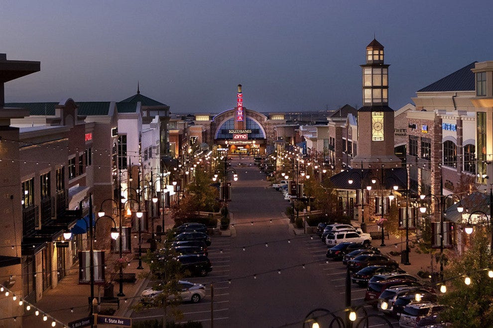
Southlands is the nicest urban center in Aurora (website). This shows the Main Street district. It looks like it has been there for 100 years, but it was built in 2005. It is the largest non-enclosed mall in the United States, with 1.7 million sq ft of retail space.
The only thing that would make it better would to add housing, like apartments, to the center. Of course it is surrounded by new housing developments, but that isn't the same thing. Also, it could use a light-rail connection. This is the sort of development we should encourage.
Compare and contrast to similar urban centers in the Denver area:
Park Meadows - It is a '90s-style enclosed mall, although one of the nicer ones. It has a light-rail connection. It is a big huge building surrounded by a sea of parking.
The Streets at SouthGlenn - A very well new-urbanism rebuild of a failed mall. Lacks housing and light-rail.
Belmar - In Lakewood, this is the probably the best example of an urban center in the country. It has lots of apartments nearby. It is only missing light-rail.
Northfield Stapleton - Has light-rail but it is not the most convenient, but there is a free shuttle. No apartments, but there are lots of new housing nearby.
Flatiron Crossing (Broomfield) - half mall, half outdoor. Well-served by high-speed buses.
Arista (Broomfield) - This isn't a retail shopping area, unlike the rest of these. It is an urban town center/transit-oriented development, with lots of housing, office space, and an entertainment arena, with high-speed buses.
Westminster Promenade - A 24-screen movie theater, with nearby brewpub restaurant, outdoor shopping district, hotel, ice rink and lake, again serviced by high-speed buses.
Verdict? Belmar is probably the best.
Saturday, April 1, 2017
New Boulevard Map

Here is my attempt at a map of the new 6-lane boulevards. Yellow is east-west and green is north-south. It doesn't show 64th Ave, Tower, Imboden, or Quail Run.
This doesn't look as impressive as the text description. Things that stand out:
1) the Quincy & Watkins form the south and east side of a giant square, with E-470 and I-70 forming the other 2 sides.
2) Gun Club will be improved up to Mississippi. Picadilly will be improved down to the 6th Avenue extension. But there is a missing piece of SH-30 between Picadilly and Gun Club that will need to be 6 lanes as well which isn't listed. Maybe I just missed it. Gun Club-Picadilly will be the free alternative to E-470. But it will be very expensive to build because of the expense of: 1) the missing link between Mississippi and 6th, which crosses E-470; 2) the complicated interchange of Colfax-I-70 and Picadilly; 3) another bridge over E-470; 4) another bridge over Pena Blvd.
3) The major north-south corridor will be Harvest. This is also almost exactly aligned with one of the north-south runways at DIA. It will run right through the middle of Aurora Highlands. It is very interesting that we are planning a major 6-lane boulevard, a freeway, really, where today there is nothing, not even a two-lane dirt road (except for two short stretches).
4) There aren't any major east-west roads south of I-70 past Harvest except for Quincy. As a corollary, the area south of I-70 seems kind of boring, with just lots of giant subdivisions planned, but not much else.
5) There will be 3 major east-west roads north of I-70: 48th, 56th and 64th (not shown). Which one of these will be the main one? Definitely 56th avenue. It is the southern border of the arsenal, and it goes east all the way to Front Range Airport. From Quebec to Imboden is about 17 miles. So I'm calling it - 56th Avenue is the new Colfax, the new east-west drag. I should do another post about that. At Front Range, the traffic will go onto 48th to drive around it, and then continue all the way to Kiowa-Bennett Rd. (From Imboden to Kiowa-Bennett is another 9 miles).
Breaking through barriers
The "psyche" of Aurora has been formed by boundaries, and then breaking them.
Problem 1 (up to 1970): Aurora was "trapped" by the Rocky Mountain Arsenal (25 sq miles) to the north, Stapleton, Fitzsimons and Lowry in the middle, and the Cherry Creek Reservoir on the south. The band of development between Stapleton and Lowry was only 9 blocks, (from 11th to Montview), and between Lowry and Cherry Creek was only 32 blocks (Alameda to Hampden). The eastern boundary of the city is really Havana.
Solution 1: (finished in 1976). Build I-225 to go around Stapleton, Fitzsimons, and Lowry. This opened up the area to the east of I-225 to development. Result: Aurora's population grew from 75,000 in 1970 to 222,000 in 1990. And the eastern boundary is pushed out to Chambers Rd, 3 miles east.
Problem 2 (up to 1990): The barriers of the Arsenal and Cherry Creek Reservoir remain, and development is now stopped by Buckley, and the Plains Conservation Center.
Solution 2: (finished 2003). Build E-470, a 47-mile toll road, at a cost of $1.2 billion, and completely bypass all of these barriers. Result: Aurora's population grew from 222,000 in 1990 to 325,000 in 2015. The eastern boundary is now E-470, another 5 miles to the east.
Problem 3 (through about 2030): Aurora is tired of growing and just wants to absorb what it has and increase the density. But forces outside its control are greedy and want to drive growth. Ok, Denver's area around DIA, we understand. But there is also Front Range Airport (Adams County), Prosper (Arapahoe County), and Lowry Range (State Land Board). These 4 entities want their piece of the pie. And you can't just ignore them. DIA is 52 square miles, with thousands of acres of land to be developed. Front Range Airport is 4,000 acres. Prosper is 5,000 acres. Lowry Range has a whopping 26,000 acres, most of which will be open space, but it still needs about 3,000 acres developed in order to raise money for schools. And don't forget about Aurora Highlands, which is 5,000 acres.
Solution 3 (about 2035): Build about 100 miles of 6-lane boulevards, that are essentially new freeways. This will push the eastern boundary all the way out to Watkins Rd, which is another 6 miles to the east.
Problem 4 (through about 2050): Ok, this is in the realm of science fiction, but it could happen. The city of Aurora, with a population of over 1 million, much bigger than Denver, needs some more "living room". It feels trapped by the Aurora Reservoir and Lowry Range to the south, and the Front Range Airport and DIA to the north. Plus I-25 is getting crowded.
Solution 4 (about 2060): Build a 200 mile north-south tollway from Pueblo to Ft Collins, about 25 miles east of I-25. Actually, this is already planned. It is called the Prairie Falcon Parkway Express, but it was killed in 2008. But it will be back in about 40 years.
New Boulevards on the Plains
To accommodate all the new mega-projects going up to the east, Arapahoe and Adams county will spend hundreds of millions on building new 6-lane boulevards. (Technically, in the Denver area, boulevards are north-south and avenues are east-west, but I am ignoring the distinction here). This is what the area will look like in 2034, if everything goes according to plan.
East-West In Adams County:
64th Avenue: Tower to Himalaya (6 lanes); Himalaya to Monaghan (4 lanes)
56th Avenue: Pena Blvd to Imboden (6 lanes)
48th Ave: Picadilly to Quail Run (6 lanes)
East-West In Arapahoe County:
6th Avenue: Airport Blvd to Harvest Mile (6 lanes)
Jewell: Himalaya to Harvest Mile (6 lanes)
Quincy: Plains Parkway to Watkins Rd (6 lanes)
North-South:
Tower Rd: 6th Ave to 105th Ave (6 lanes)
Picadilly: 6th Ave to 120th (6 lanes); Jewell to 6th Ave (4 lanes)
Gun Club: Quincy to Mississippi (6 lanes)
Harvest/Harvest Mile: Jewell to 64th (6 lanes)
Powhaton: none
Monaghan: Quincy to Yale (6 lanes)
Watkins Rd: Quincy to I-70 (6 lanes)
Imboden: 48th to 56th (6 lanes)
Quail Run: I-70 to 48th (6 lanes)
Source: https://drcog.org/sites/drcog/files/resources/2040%20RTP%20Appendix%204.pdf
In a future post, I will make a map of these to visualize them better.
6 lanes is very wide for a boulevard. I think I-70 is only 4 lanes east of Pena Blvd.
Subscribe to:
Posts (Atom)